

Flambeau River South Fork
(FS1) Lugerville to County W Bridge, Wisconsin Trail Guide
Trail Facts
| Distance: | 9.3 miles |
| Skill Level: | Novice |
| Whitewater: | Class II |
| Approx. Paddle Time: | 4 hours |
| Elevation Drop: | 42 feet |
| Average Gradient: | 4.5 fpm |
Synopsis
Trail Review
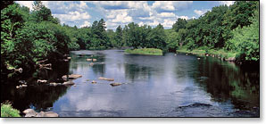
Despite the fact this segment lies outside the boundaries of the Flambeau River State Forest, there is very little development along the shoreline. Tall and dense shrubs, thickets and marsh grasses often surround the river, backed by lush forests. Where the forest overhangs the riverbanks, maple, basswood, ash, and stands of mixed pine and spruce provide a canopy. Homes and cottages occasionally appear on the left bank in the first three miles.
The river runs fairly narrow in this segment and there are six named rapids; Stonewall Rapids, a class II, presents the greatest challenge about a mile and a half below Lugerville. More pitches of rapids and riffles occur throughout this reach, interspersed with occasional long stretches of flatwater.
The South Fork is far 'less-traveled' than the more popular North Fork, so you are less likely to see other paddlers on the river. Especially in this segment.
Canoe/Kayak Camping
This segment lies outside the boundaries of the Flambeau River State Forest and has no canoe camps.
Season
The best paddling is usually from late-spring through June. Water levels tend to fluctuate more in the South Fork than the North Fork, and the rapids in the South Fork seem more dependant on rainfall, but should be navigable throughout the early summer months. Some rapids will be scrappy in late summer! Very high water levels can produce hazardous waves in several of the rapids.
River Level Information
Phone Contact for River Info: Flambeau River State Forest HQ: 715.332.5271
USGS Website: There is no USGS River Gauge for this segment.