

Flambeau River North Fork
(FN2) 9 Mile Creek Landing to Dix Dox Landing, Wisconsin Trail Guide
Trail Facts
| Distance: | 11.4 miles |
| Skill Level: | Easy |
| Whitewater: | Class I |
| Approx. Paddle Time: | 4-5 hours |
| Elevation Drop: | 43 feet |
| Average Gradient: | 3.8 fpm |
Synopsis
Trail Review
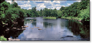
This segment of the Flambeau River North Fork is wide and slow, providing a great float for flat-water canoers and kayakers. Barnaby Rapids, an easy class 1 boulder garden, is the only whitewater in this stretch. For anglers, walleye and smallmouth can be found along the edge of weed lines and in the numerous eddies, while musky can be pulled from several deep holes.
This entire segment runs through the Flambeau River State Forest. Paddlers will find very few signs of development along the banks as the river flows through a dense forest of maple, oak, ash and mixed pine. A pair of shaded, canoe/kayak-access riverside campsites offer overnight camping, each with their own fire ring and picnic tables.
Canoe/Kayak Camping
This segment has two canoe camps. The camps are well-maintained and each offers three separate campsites, most have plenty of shade. Each camp has a pit toilet, and each site has a fire ring and a picnic table. The sites are available on a first-come, first-served basis and are limited to a one night stay. There is no fee for camping. Glass beverage containers should not be used on the river!
Season
Generally good paddling throughout spring, summer and fall.
Less experienced paddlers should avoid the river during the winter melt-off in early spring, and after a sustained heavy rainfall. Call the WDNR State Forest Office at 715.332.5271 for water level information.
River Level Information
Phone Contact for River Info: Flambeau River State Forest HQ: 715.332.5271
USGS Website: There is no USGS River Gauge for this segment.