

Flambeau River South Fork
(FS2) County W Bridge to County M Wayside, Wisconsin Trail Guide
Trail Facts
| Distance: | 7.4 miles |
| Skill Level: | Intermediate |
| Whitewater: | Class II-III |
| Approx. Paddle Time: | 3-4 hours |
| Elevation Drop: | 31 feet |
| Average Gradient: | 4.2 fpm |
Synopsis
Trail Review
Paddlers will find long stretches of flatwater with scattered boulder gardens, and several pitches of rapids that often occur in narrow wavy constrictions. The most challenging whitewater occurs near the end, at Prison Camp Rapids, a solid class II which rates class 3 during high flows. Two other rapids are worth noting: Cornsheller Rapids - a rocky class II, and Price Creek Rapids - another bouldery class II.
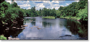
This segment passes through a remote, wild area with beautiful scenery! There are few signs of human development - most of which occurs near the beginning. The river flows through a mixed hardwood forest with frequent stands conifers. Beautiful rock formations overlook Prison Camp Rapids, a highlight of this segment.
A large number of islands split the river; a few are long and narrow and lie beneath a dense forest canopy, some are covered in tall grasses and thickets, while others are bouldery rock piles.
Canoe/Kayak Camping
The river crosses into the Flambeau River State Forest about halfway through this segment. However, there are no canoe camps.
Season
The best paddling is usually from late-spring through June. Water levels tend to fluctuate more in the South Fork than the North Fork, and the rapids in the South Fork seem more dependant on rainfall, but should be navigable throughout the early summer months. Some rapids will get bumpy in late summer! Very high water levels can produce hazardous waves in several of the rapids.
River Level Information
Phone Contact for River Info: Flambeau River State Forest HQ: 715.332.5271
USGS Website: There is no USGS River Gauge for this segment.