

Flambeau River North Fork
(FN1) Robinson Landing to Agenda Landing, Wisconsin Trail Guide
Trail Facts
| Distance: | 13.8 miles |
| Skill Level: | Novice |
| Whitewater: | Class II |
| Approx. Paddle Time: | 6-8 hours |
| Elevation Drop: | 53 feet |
| Average Gradient: | 3.9 fpm |
Synopsis
Trail Review
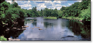
Beginning at the southwest end of the Turtle-Flambeau Flowage, this segment of the Flambeau River, North Fork passes through a rugged, wild and beautiful backcountry. The river is surrounded by a dense forest of hardwoods and stands of mixed pine. Numerous spring-fed creeks feed into the river.
Novice canoers and kayakers with whitewater experience will enjoy the numerous class 1 and 2 rapids and boulder gardens. Most of the whitewater occurs in tight, rocky constrictions between tall rocky ledges, spilling into wide scenic pools before rushing through more narrow cascades. The beautiful scenery and easy rapids combine to create one of the more enjoyable low-hazard whitewater paddle trips in the state.
Canoe/Kayak Camping
There are no canoe/kayak campsites in this segment.
Season
Generally good paddling throughout spring, summer and fall.
This segment will get scrappy during lower flows. Less experienced paddlers should avoid the river during the winter melt-off in early spring, and after a heavy rainfall. High water levels can produce dangerously high waves in several of the rapids. Call the WDNR State Forest Office at 715.332.5271 for water level information.
River Level Information
Phone Contact for River Info: Flambeau River State Forest HQ: 715.332.5271
USGS Website: There is no USGS River Gauge for this segment.