

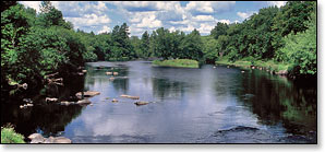
Flambeau River South Fork
(FS3) County M Wayside to Hervas Camp Landing (North Fork), Wisconsin Trail Guide
Trail Facts
| Distance: | 8.3 miles |
| Skill Level: | Advanced |
| Whitewater: | Class IV |
| Approx. Paddle Time: | 3-4 hours |
| Elevation Drop: | 56 feet |
| Average Gradient: | 6.8 fpm |
Synopsis
Trail Review
The most challenging whitewater of the entire Flambeau River is found in this segment. The rapids begin in earnest within a half-mile from the put-in where a short set of boulder gardens lead into a right bend and the river constricts between scenic rock formations and rumbles into Slough Gundy Rapids. This frothy class II-III can develop pushy waves in high water!
A short stretch of boulders follow, then the river forks around a small wooded island where the main flow goes down the right fork and roars into Little Falls. The falls rate a strong class 3 in medium flows and grows into a class 4 screamer in high water. Scout the falls from the right bank. Portage if you have any doubts!
Downstream from the Falls, the river runs through a long series of class II rapids and boulder gardens named Scratch Rapids. Further downstream, class 1 Gunners Rapids begin in a left bend and end as you approach the first of a series of grassy islands.
More shallow riffles and easy boulder gardens occur over the next three and a half miles until the confluence with the North Fork. Nothing in this final stretch compares with the first three miles.
Advanced kayakers who wish to only do the short action run through Slough Gundy and Little Falls can leave your cars in the 'Little Falls, Slough Gundy Scenic Area' parking lot and take the short hike in to the river. The small trail system here makes it easy to run the rapids and falls over and over.
Canoe/Kayak Camping
There are no state forest canoe camps on the South Fork. There are three State Forest camps after the forks confluence, in the final two miles of this segment.
Season
The best paddling is usually from late-spring through June. Water levels tend to fluctuate more in the South Fork than the North Fork, and the rapids in the South Fork seem more dependant on rainfall, but should be navigable throughout the early summer months. Some rapids will be scrappy in late summer! Very high water levels can produce hazardous waves in several of the rapids.
River Level Information
Phone Contact for River Info: Flambeau River State Forest HQ: 715.332.5271
USGS Website: There is no USGS River Gauge for this segment.