

Flambeau River North Fork
(FN4) Camp 41 Landing to Beaver Dam Landing, Wisconsin Trail Guide
Trail Facts
| Distance: | 10.9 miles |
| Skill Level: | Intermediate |
| Whitewater: | Class II-III |
| Approx. Paddle Time: | 4-5 hours |
| Elevation Drop: | 69 feet |
| Average Gradient: | 6.3 fpm |
Synopsis
Trail Review
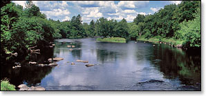
This is a wonderfully scenic trip that features a large number of rapids and boulder gardens which are suitable for 'whitewater-experienced' novice paddlers. The river continues to flow through a lush, dense, hardwood and conifer forest. Gravel bars and wooded islands continue to populate the river.
A pair of named class II rapids occur in the first three miles; Wanigan Rapids 3rd Pitch, and Flambeau Falls Rapids just below Dodes Island. A long stretch of flatwater with intermittent shallow riffles follows.
The South Fork confluence is just under four miles from the Camp 41 put-in, and the river widens considerably with the additional flow. The first pitch of Cedar Rapids occurs a little more than three miles downstream from the confluence. This challenging class II features a short series of tricky ledges through a right bend around a small island! There are a couple of stealth boulders to watch out for in higher flows!
More named rapids occur about once every mile as you continue downstream including Beaver Dam Rapids (class II), a river-wide ledge with a three-foot drop. Beaver Dam will rate class III in high flows. Scout from the left bank. Inexperienced paddlers may want to portage this one (the portage is short).
Canoe/Kayak Camping
This segment has six canoe camps. The camps are well-maintained and each offers three separate campsites, most have plenty of shade. Each camp has a pit toilet, and each site has a fire ring and a picnic table. The sites are available on a first-come, first-served basis and are limited to a one night stay. There is no fee for camping. Glass beverage containers should not be used on the river!
Season
Generally good paddling throughout spring, summer and fall.
Several rapids in this segment will be scrappy during lower flows. Less experienced paddlers should avoid the river during the winter melt-off in early spring, and after a sustained heavy rainfall. Call the WDNR State Forest Office at 715.332.5271 for water level information.
River Level Information
Phone Contact for River Info: Flambeau River State Forest HQ: 715.332.5271
USGS Website: There is no USGS River Gauge for this segment.