The Black River
The Black River is the centerpiece of Pattison State Park. Not to be confused with the 200-mile tributary of the Mississippi River, this Black River begins in northwest Wisconsin near the Minnesota border at Black Lake and runs north for twenty-eight miles until it enters the Nemadji River, which eventually flows into Lake Superior.
A 3.5 mile stretch of the river flows through Pattison State Park where the gradient steepens and the river roars through long stretches of rapids and several scenic waterfalls. The first waterfall occurs at Little Manitou Falls (31 feet), followed by a long, scenic stretch of boulder gardens, rapids and minor falls. Eventually, the river slows and widens into beautiful Interfalls Lake, where a spruce, pine, and hardwood forest surrounds clear waters and weed-bed islands.
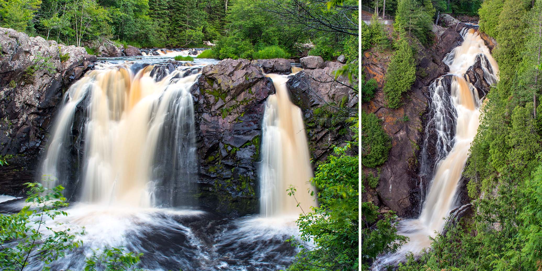
The river continues through a small dam at the northwest corner of the lake and quickly plunges 165 feet over Big Manitou Falls, the fourth highest waterfall in the U.S. east of the Rockies. The falls spill into a rocky, sandstone gorge that continues until the Nemadji River confluence, five miles downriver.
At only twenty-eight miles in length, the Black River is supported by a small watershed so water levels can vary dramatically depending on the season and weather. In spring and after heavy rainfalls during summer and fall, the river and falls inside Pattison State Park will be a roaring inferno. The rest of the time, especially summer and fall, the rapids and falls present a beautiful display of copper-tinted, tumbling waters that are well-worth visiting.
Though the river water is copper-colored, the tint is caused by tannins from decaying vegetation along the river, not copper.
Big Manitou Falls
Big Manitou Falls drop 165 feet in two distinct stages over a basalt escarpment into a deep basin. Pines, cedar, and spruce surround the falls and cover the walls of the escarpment creating gorgeous scenery. Below the falls, the river flows out of sight around a sharp bend, running north into narrow sandstone canyon known as ‘Rocky Gorge'.
A small network of paved pathways lead to several overlooks offering excellent views of the falls from both sides of the basin rim. The best views of the falls are from the overlooks on the west side of the river. A pedestrian tunnel under Highway 35 provides access to the waterfall paths from the Park’s main visitor and parking area. A footbridge crosses the river between the head of the falls and the highway, providing easy access to both sides of the gorge. A smaller parking area, closer to the falls, is on County Highway B.
The Douglas Fault
The escarpment that forms Big Manitou Falls and the rocky gorge below are remnants of two ancient geologic events. First, approximately 1.2 billion years ago, lava flows covered the surrounding region. Over time the flows cooled and hardened. Then, about 500 million years ago, a massive fracturing of the bedrock occurred in a series of giant earthquakes. Today, this fracture is named the Douglas Fault, and starts on the floor of Lake Superior just north of Ashland and extends in a long westward arc to just north of the Twin Cities in Minnesota. A fantastic interpretive guide on the geology of the area can be downloaded here or is available in printed format at the Pattison State Park office.
Little Manitou Falls
Little Manitou Falls are one mile upriver (south) from Interfalls lake. By vehicle, the parking and visitor area are one mile south of the main park entrance on Highway 35. The falls occurs where the Black River drops thirty-one feet over a wide ledge into a small basin surrounded by black basalt walls, pines, cedar and hardwoods. An accessible overlook provides unobstructed views of this scenic waterfall and basin. During normal summer flows, it’s possible to scramble down to the edge of the spill pool, just be careful on the loose, wet rocks.
Little Manitou Falls has its own visitor area with two paved parking lots, drinking water, restrooms (vault toilets), and a large, shaded picnic grounds with tables and grills.
Interfalls Lake
Scenic Interfalls Lake is a small flowage (23 acres) created by the dam at its northwest corner. The entire lake lies within the State Park and is surrounded by boreal forest with an area of upland forest on the northwest shoreline. The Park’s main day use area is on the north shore and features a wide sandy swimming beach and an expansive, shaded picnic grounds.
Exploring the non-motorized lake by kayak or canoe is a fun and popular activity, and paddleboarding is excellent on less-windy days. A sandy launch area is at the east end of the beach.
CCC Shelter Building
& Gitche Gumee Nature Center
The historic Shelter Building houses a nature center and an enclosed, reservable shelter. The Gitche Gumee Nature Center features displays and exhibits that describe the area’s wildlife, geologic history, and human history, from prehistoric times to the Civilian Conservation Corps.
The reservable shelter is clean, well-maintained and offers lacquered benches and picnic tables, two giant stone fireplaces, electric lighting, electric outlets, and restrooms.
A commemorative sign at the southwest corner of the building describes the hard work that went into its construction:
“This building was built by Company 3663 of the Civilian Conservation Corps, starting in 1937, at cost of $60,000, using 128,00 man-days of labor.
Men used chisels and 14-pound sledge hammers to break large rocks into stones. The stones were then transported to the park where “finishers” cut the stones into blocks to meet specifications of the masons.
With hammers and chisels, they carefully shaped the stones. Four finished stones per man was considered a good days work.”
The Trails
It is easy to come to Pattison State Park and only visit the two main attractions, Big Manitou Falls and Little Manitou Falls, however the Park has much more to offer. A highly recommended hike combines the Beaver Trail, Little Falls Trail, and the Big Manitou Falls Trail for a total distance of 3.5 miles. This hike will showcase the most scenic features of the Black River as it flows through the Park, including Interfalls Lake, long stretches of boulder gardens, rapids, and minor falls, Little Manitou Falls, and finally Big Manitou Falls.
A great starting point is at the trailhead in the pet picnic area next to the campground. From there, hike south on the Beaver Trail until it crosses the footbridge over the Black River, at the junction, head south on the Little Manitou Falls Trail to view some fantastic river scenery and Little Manitou Falls. Return on the same trail, and then head north on the west leg of the Beaver Trail to the pedestrian tunnel under Highway 35. Cross under the highway and explore the pathways and overlooks around Big Manitou Falls. When you’re finished at Big Manitou, cross back through the tunnel and stroll through the picnic grounds on the north shore of Interfalls Lake on your way back to your vehicle or campsite.
Big Manitou Falls River Trail
(out-&-back)
Distance
Difficulty
Elevation Gain
& Packed Dirt
Trail Surface
The Big Manitou Falls River Trail begins at the northernmost Big Manitou Falls overlook on the west rim and leads downhill into Rocky Gorge. The hike passes through a pine and hardwood forest and crosses several boardwalks and footbridges over seasonal streambeds. The trail ends inside the gorge at a wooden stairway on the rocky shore of the river. Ancient, colorful, sandstone cliffs tower over the opposite bank.
Beaver Trail
(loop)
Distance
Difficulty
Elevation Gain
& Packed Dirt
Trail Surface
This scenic trail would be a destination hike on its own if it was located anywhere else, here it is overshadowed by Big Manitou Falls and Little Manitou Falls. The Beaver Trail circles Interfalls Lake and a short segment of the Black River. Much of the trail passes through a boreal forest of cedar, spruce, balsam fir and pines where it nears the lake and river. Hardwoods and pines canopy the trail on higher ground. Fern beds often surround the trail.
The east leg of the loop features several panoramic views of Interfalls Lake. At the south end of the loop, a footbridge crosses the river in an especially scenic area. The trail follows the river on both sides north of the bridge. Boulders and basalt ledges make up the riverbed throughout this stretch. The rocky river scenery, pine-scented air, and the sounds of the rushing waters create a fantastic, relaxing atmosphere.
The north trailhead of the Little Manitou Falls Hiking Trail is a few steps from the west end of the footbridge. This trail runs south (upstream) along another scenic stretch of the river to Little Manitou Falls.
The Beaver Trail trailhead is in the Pet Picnic Area near the lake. However, you can access the trail from numerous places throughout the park. Most of this developed trail is crushed stone with stretches of packed dirt and is usually 4 to 6 feet wide.
Little Manitou Falls Trail
(point-2-point)
Distance
Difficulty
Elevation Gain
& Packed Dirt
Trail Surface
The Little Manitou Falls Trail is a fantastic short hike that follows the Black River below Little Manitou Falls, and connects with the Beaver Trail at its north end. The river has a steep gradient in this stretch and features numerous rapids and minor waterfalls. Cedar, balsam fir, spruce, white pine, birch, and aspen surround the river and trail. Footbridges and boardwalks cross tiny streams and seasonal stream beds. The trail runs directly along the river and will reward you with beautiful small-river scenery.
Overlook Trail
(lollipop loop)
Distance
Difficulty
Elevation Gain
& Packed Dirt
Trail Surface
This forest hike features a trailside overlook of the Black River through leafy vegetation. There is a bench to sit, rest and enjoy the view. If you’ve hiked up from the Beaver Trail, you’ll likely be surprised at how much elevation you’ve gained above the river. This trail also provides access to the Oak Ridge Trail, River View Trail, and the backpack campsites.
There are a couple of ways to access the Overlook Trail. The trailhead is at the southwest corner of the campground across from site #7. A small parking area has room for about three vehicles next to a sign that reads “Ski Trail”. The second, and more scenic access (during summer), is from the east leg of the Beaver Trail. A wide, gravel spur leads up a steep incline and connects with the Overlook Trail at the top of the small rise.
Oak Ridge Trail
(point-2-point)
Distance
Difficulty
Elevation Gain
Trail Surface
The west segment of the Oak Ridge Trail traverses the side of a sloping hill through an oak and conifer forest. A three-sided shelter is at the south end of the loop, a few steps from the spur that leads to the backpack camping area. A high canopy of mature maple and oak shade the east segment of the trail. A light understory allows hikers to see for long distances into the forest.
For information on the backpack campsites, please visit the Camping page.
River View Trail
(point-2-point)
Distance
Difficulty
Elevation Gain
Trail Surface
The River View Trail is for those who enjoy the path less traveled. Rewards are solitude and views of the quiet Black River where tall grasses and huge fern beds surround the slow-moving waters. Most of the riverbed is a fine golden sand with occasional rocky shoals and boulder gardens.
North of the river, a long segment of the trail passes through an area of rolling hills where tall maples and hardwoods shade a light understory giving hikers excellent visibility in all directions into the scenic forest.
Winter
During winter, the Overlook, Oak Ridge and River View Trails are groomed for cross country skiing.
Recreation & Attractions
Black River, Big Manitou Falls, Little Manitou Falls, Rocky Gorge, scenic river area (rapids & minor falls), Interfalls Lake, swimming, lake paddling, picnicking, boreal forest, hiking, tent & RV/trailer camping, backpack camping, Gitche Gumee Nature Center, cross-country skiing, snowshoeing
Amenities
Park Office
Staffed office, information, restrooms (running water, accessible flush toilets), firewood (fee $)
Interfalls Lake & Big Manitou Falls Day Use Areas
Parking, drinking water (water fountains with spigots), restrooms (running water, accessible flush toilets), accessible vault toilets, reservable indoor shelter (electric lighting & outlets, soda vending machines), bathhouse (running water, accessible flush toilets, changing stalls), accessible pathways (paved & crushed stone), picnic grounds (shade, lawn, tables, grills), swimming beach, children's playground, pet picnic area (shade, lawn, tables, grills, lake access), sand volleyball court, horseshoe pits, basketball halfcourt, dump station
Little Manitou Falls Day Use Area
Parking, drinking water (water fountains with spigots), restrooms (running water, accessible flush toilets), accessible pathways (paved & crushed stone), picnic grounds (shade, lawn, tables, grills),
Campground
59 campsites (18 electric, 41 non-electric), shower building (running water, accessible heated showers, accessible flush toilets), accessible vault toilets, garbage & recycling
Backpack Campsites
3 campsites, vault toilets, shelter
Managing Agency & Info
- Wisconsin DNR
- Pattison State Park
6294 S State Rd 35
Superior, WI 54880 - Hours: Pattison State Park is open year-round from 6 a.m. to 11 p.m.
- Phone: 715.399.3111
- Official Website: Pattison State Park
- Access Fee: Yes
A Wisconsin State Park System vehicle admission sticker is required on all motor vehicles stopping in state parks, forests and recreation areas (daily or annual).
Trails & Places
- Amnicon Falls State Park | Scenic waterfall area, camping
- Bois Brule River | Paddling, camping
- NCT Brule Portage Trail & Boardwalk | Hiking
- St Croix River | Paddling
- COGGS | Mountain biking
- Jay Cook State Park | Scenic river gorge