The Amnicon River
A beautiful, rugged, 2-mile stretch of the Amnicon River drops more than 200 feet over the ancient Douglas Fault through Amnicon Falls State Park. There are several named waterfalls, big rapids, dalles, rock formations, a small sandstone canyon, and a historic Horton Bridge. The combination of tall pines, close proximity of the waterfalls and the large number of overlooks and viewing points make this one of the most scenic and easy-to-view waterfall areas in Wisconsin.
The Park’s sprawling day use area features numerous shady picnic spots close to the river in attractive settings among red and white pines; tables, grills and firepits often sit next to scenic rapids. This is a great place for families and groups to spend an afternoon relaxing and exploring.
Waterfall Trails
The Amnicon River splits into three channels where it flows through the main visitor area inside the State Park. The tiny, seasonal east channel forms only when river levels are high enough and has the appropriately named “Now and Then Falls”. The main, central channel has the largest flow by far and features “Upper Falls”, “Lower Falls” and the covered Horton Bridge, the park's main attractions. The smaller, west channel features “Snake Pit Falls” and several smaller waterfalls.
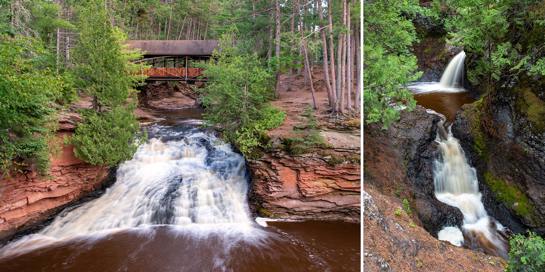
In the main channel, Upper Falls (20 feet) occurs after a long stretch of big, rocky rapids, where the river narrows and plunges 20 feet into a wide pool surrounded by black, basalt walls. An accessible overlook, several viewpoints and the Horton Bridge provide excellent views of this waterfall.
Below Upper Falls, the river passes under the Horton Bridge and rushes over Lower Falls (20 feet), a wide rocky slide that spills into a scenic sandstone canyon surrounded by birch, cedar and tall pines. A flat-topped ledge below the falls offers fantastic views of the bridge, waterfall, and the colorful layered walls of the small canyon.
Notice the striking difference between the rocks surrounding Upper Falls and Lower Falls.
In the narrow west channel is Snake Pit Falls (25 feet), a combination of two small waterfalls split by a scenic plunge pool in a black, rocky bowl. The upper waterfall and pool and are the easiest to view. The lower waterfall drops into a narrow and deep, mini-gorge which ends after about 50 yards, where the flow rejoins the main channel. Snake Pit Falls are the highest waterfall in the park but receive much less waterflow than Upper and Lower Falls.
The small but scenic, Now and Then Falls (8 feet) is in the seasonal east channel and forms only when river levels are medium or higher. Be sure to check out the moss-covered rock formations about a hundred yards below Now and Then Falls.
The walking distance to view all the named waterfalls in the park is less than a mile, and the terrain is mostly flat. The minimal understory beneath the high canopy of pines make it easy to stray from the trails and wander from one scenic spot to the next.
Horton Bridge
A uniquely designed, fifty-five foot bridge spans the river between Upper Falls and Lower Falls. The original bridge had no roof and was built where a county highway used to cross the Amnicon River. The bridge was moved here in 1930, had a roof installed in 1939, and was the site of social events and organized parties thrown by the locals for several years.
The bridge was designed by inventor Charles Horton who was a brief resident of Superior in 1897 and 1898 before settling in La Crosse, WI. His unique bridge design called for the use of arched support beams as well as hook clips instead of rivets and bolts. He claimed this made the bridge cheaper, stronger and easier to build. This style of bridge became known as a "Horton" or "Bowstring" bridge. Only six bridges of this type exist today, the other five are located in the Van Loon Wildlife Area near La Crosse.
Thimbleberry Nature Trail
This nature trail features a variety of scenery in a relatively short hike. The trailhead is across from the park headquarters and the campground entrance, making this a popular hike for campers.
The first scenic feature of the trail occurs only a short distance from the trailhead, where a short spur leads down to an intimate dalles with waterfalls, pools, and scenic formations in the small west channel of the Amnicon River.
Further along, the trail follows the Amnicon below the main waterfall area, passing over low ridges with overlooks offering views of the river below. A few short stretches are close to the river allowing hikers to scramble onto the rocky riverbed during normal summer flows.
Another spur near the northwest end of the loop leads to a deep pond that was a sandstone quarry from 1887 to 1907. A sign details a brief history of the quarry and its operations:
“At the turn of the century, sandstone, also called brownstone, was a popular construction material. This quarry was established in 1887 and during its 20 years of operation it produced over a million cubic feet of stone that was shipped to Superior, Duluth, Chicago, Sioux City, Omaha, St Paul, Minneapolis, and other midwestern cities. Fairlawn mansion and museum in Superior was built with brownstone from this pit.
The quarry camp was located between here and the nature trail. Watch for the building site on your left as you return. A blacksmith shop and other buildings once stood on the other side of the trail.
Along the main trail you will pass through a meadow that was the railroad loading yard. A spur grade, with a switchback, allowed the loaded trains to reach the main line, now the Tri-County Recreation Corridor. During high water, the stone blocks were also sent down the Amnicon River on barges”
Source: Wisconsin DNR
Away from the river, the trail meanders through a hardwood and pine forest, a meadow filled with wildflowers and a dense stand of balsam fir where beavers used to harvest trees for their lodges. There are interpretive signs detailing the flora, fauna and history of the area.
Overall, expect hilly terrain, especially near the river. Anti-erosion steps are built into the steeper inclines, and footbridges and boardwalks cross seasonal streambeds. The trail is easy to follow and most of the surface is packed earth or gravel.
Recreation & Attractions
Amnicon River, Upper Falls, Lower Falls, Snake Pit Falls, Now & Then Falls, Sandstone canyon, Horton Bridge, Thimbleberry Nature Trail, sandstone quarry, scenic pine forest, hiking, picnicking, camping (tent & RV/trailer), snowshoeing
Amenities
Park Office
Staffed office, information, restrooms (running water, accessible flush toilets), parking
Waterfall Areas
Parking, reservable shelter, drinking water, accessible vault toilets, accessible overlook, picnic grounds (shade, tables, grills, firepit), children's playground
Campground
35 campsites (non-electric), drinking water (water fountains with spigots), accessible vault toilets, children's playground
Park Information
- Wisconsin DNR
- Amnicon Falls State Park
- 4279 South County Highway U
- South Range, WI 54874
- Phone: 715.398.3000
- Official Website: Amnicon Falls State Park
- Permit / Access Fee: Yes, WDNR Vehicle Admission Sticker Required (Daily or Annual)
- Park Hours: Open 6:00am to 11:00pm year-round
- Headquarters GPS: 46.608969, -91.892328
Trails & Places
- Pattison State Park | Waterfalls, hiking, scenic river, lake, camping
- Bois Brule River | Paddling, camping, trout fishing
- Bear Beach State Natural Area* | Scenic beach
- NCT Brule Portage Trail & Boardwalk* | Hiking
- St Croix River | Paddling
- COGGS* | Mountain biking
- Jay Cook State Park* | Scenic gorge