Sandy Beaches & Scenic Rock Formations
Beginning at Black Lake in Taylor County, the Black River flows for nearly 200 miles before joining the Mississippi River near Onalaska. The upper Black is narrow and intimate, trees often arch overhead creating a tunnel-like effect. Maple, beech, birch, and ash cover a varied understory, while pine and spruce canopy the banks where the soils are sandy. This long upper region features numerous riffles, class 1 rapids, small islands, and weedy gravel bars. The islands often create narrow, bending, high-speed chutes that can be fun, yet sometimes dangerous due to fallen trees and strainers.
The surrounding landscape becomes more hilly as the river runs past Greenwood and Neillsville. The rapids become more difficult as well. Paddlers will find numerous pitches of fun class II's when water levels are adequate, which is usually in the spring and early summer. Several of the rapids rate class III in high flows, especially during the winter melt-off.
The first of two dams on the lower Black River is located at Hatfield, which forms Lake Arbutus, a beautiful and popular summer destination for summer vacationers! Picturesque rock formations, and gorgeous stands of tall white pines are located along the river, above and below Lake Arbutus.
The steepest gradient of the river lies in the eight mile stretch below Lake Arbutus, south of the Hatfield Dam. Kayakers will find at least four class IV rapids and a number of class II's in this short reach when water levels are high. These rapids are best run in the spring or when the Hatfield dam has a release.
The difficult whitewater ends a few miles above Hall's Creek Landing, and the character of the river changes to wide, shallow, and slow; though the river bed continues to be rocky. Below Hall's Creek, the river flows between rock formations that become more dramatic as the river approaches the Black River Falls Dam (the second, and final dam on the Black). The river in this stretch is mostly quietwater with a few riffles and one class I rapid.
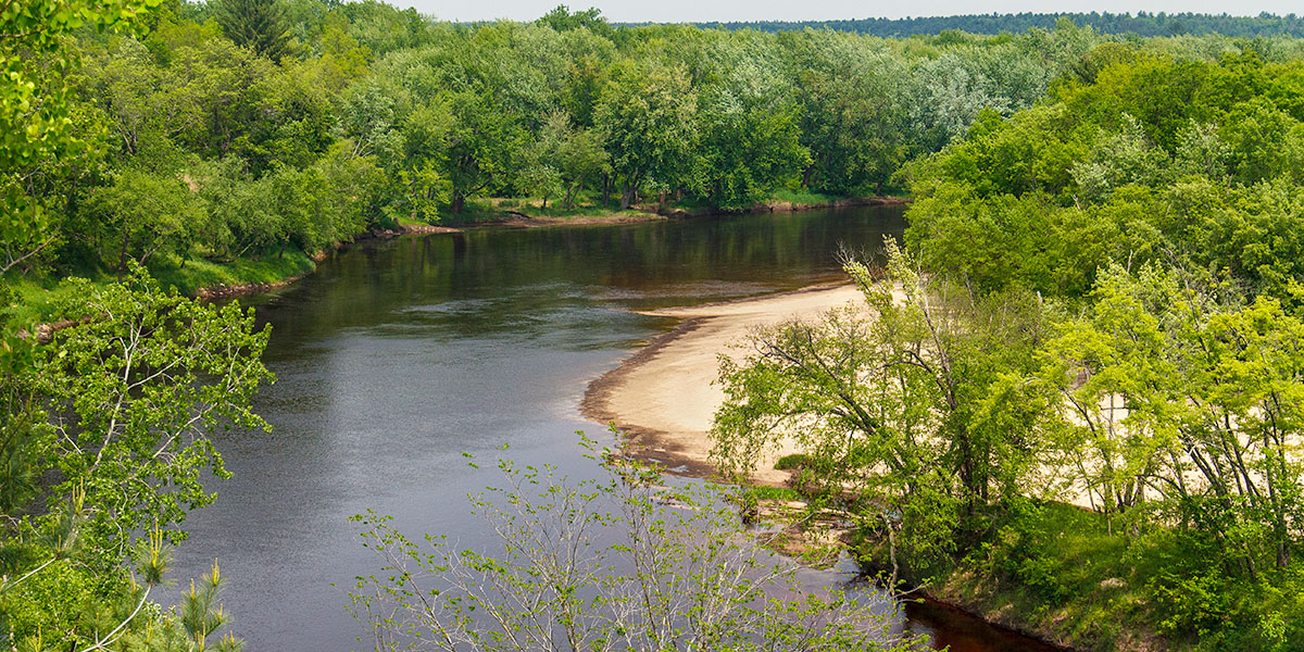
Below Black River Falls, the calm waters of the lower Black run through a geologically unique area of Wisconsin, where the northern range of southwest Wisconsin's driftless region - with its tall scenic bluffs and rock formations - overlaps the southern edge of Wisconsin's northern hardwood-conifer forests. Here you will find the most popular segments of the Black River for canoeing and kayaking, including the 21 mile stretch between Irving and North Bend, where sandbars and sandy beaches seem to appear around every bend and the sandy river bottom is often a few inches below the water's surface (normal summer flows). This part of the river is also popular for canoe camping excursions. Overnight camping on islands and island sandbars is permitted. There are enough access points along the lower Black River that you can plan a trip that could last a few hours or several days.
The river is also popular for fishing. Numerous, deep pools and submerged deadfall in the river provide plenty of opportunities for anglers to fish for small mouth bass, northern pike, and musky.
The Black River Falls/Lake Arbutus area offers plenty of outdoor recreational activities besides paddling. The Black River State Forest and the Wazee Lake Recreation Area feature a number of scenic hiking, mountain biking, and horse trail systems. The 'Foundation Trail', located in Black River Falls, is one of the best rural, paved walking/biking trails in Wisconsin.
Other area attractions include motorcycle and atv trails, numerous fishing lakes and streams, boating, water skiing, a community theater, and the Ho-Chunk Majestic Pines Casino for night-time entertainment.
River Camping
The lower Black is well-known for its large number of inviting sandy beaches and its shallow, sandy river bottom. However, most of the lands surrounding the river are private property and camping on any shoreline beaches, meadows, or open areas outside of state-owned property is trespassing. Wisconsin State Law allows camping for up to three nights on islands, island beaches, state forest and state recreation area shorelines.
If you plan on camping on state-owned lands or beaches, please check the weather report and get a water-level forecast from a local outfitter or the Black River State Forest before you embark on your trip.
The Black River State Forest maintains a small, primitive canoe campground for overnight camping in segment BK2, below Hawk Island. The camp offers two tent sites. Each site has a picnic table, fire ring and a shared toilet. Camping is free and operates on a first-come, first-served basis. You must limit your stay to one night only!
Three privately owned campgrounds are below Black River Falls in excellent locations for overnight canoe camping. You will want to reserve a campsite in advance:
Lost Falls Campground*
The English Pale Resort & Campground*
Champions Riverside Resort*
Black River State Forest Campgrounds
All three family campgrounds in the Black River State Forest are within a short driving distance of the Black River. Closest to Black River Falls is Castle Mound, a beautiful well-maintained campground that is open year-round and offers 35 total sites (14 electric). The campground sits in a pine and hardwood forest and is part of a recreation area that features the popular Castle Mound Nature Trail and Overlook. For those paddling the Black River, the Holmgreen and Bruce Cormican Landings are less than 2.5 miles away.
Facilities include an accessible shower building with accessible flush toilets and sinks with running water, drinking water, vault toilet buildings, firewood ($), an enclosed picnic shelter with electricity, garbage, recycling, and a dump station that is free for all registered campers in the State Forest. There is also a shady picnic area with a children’s playground.
East Fork (24 sites) is a scenic, shady campground located next to the East Fork Black River. More than a dozen sites have direct river access, and several have open views of the river. Two separate group camping areas include the ‘Indoor Group Campground’ which features a clean but rustic, four-season cabin that sleeps up to 12 people, and an outdoor tent area that can accommodate an additional 13 people. The second group site is the ‘Outdoor Group Camp’, which has a large tent area with a 50-person maximum. East Fork’s facilities include vault toilets, drinking water (hand-pump), firewood ($), garbage, recycling, a shady picnic area and a carry-in canoe landing.
Pigeon Creek (38 sites) is an excellent family campground in a pine and hardwood forest next to a pond named Pigeon Creek Flowage. There are no waterfront sites, but every site has a flat spur and tent area. All sites are at least partially shaded. Campground facilities include vault toilets, drinking water (hand-pump), firewood ($), garbage, recycling, picnic area and a sandy swimming beach.
The Smrekar and Wildcat trailheads for the popular Black River State Forest Loop Trails (hiking, mountain biking) are less than 4 miles from the Pigeon Creek Campground by vehicle. The large trail system offers multiple loop trails that go around and over a long, wooded ridge that features scenic rock formations and several overlooks. A 3-mile (one way) gravel pedestrian trail connects the campground to the Smrekar Trailhead at the south end of the trail system.
Season
The river is usually navigable throughout spring, summer and into fall. It can be scrappy in places during periods of little rainfall in late summer and fall. Contact a local outfitter or the Black River State Forest for information before you paddle.
River Level Information
Phone: Black River State Forest: 715.284.4103.