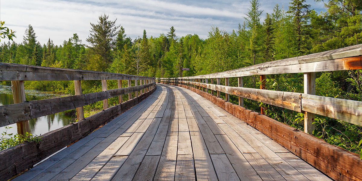
The Bearskin Creek, Trestles, and Forests
The Bearskin State Trail is a beautiful, 27-mile-long pedestrian trail from Minocqua to Heafford Junction on a scenic railroad bed with a short section below Highway 51 that shares rural roads. Development is limited along the trail, especially south of Hazelhurst, making this a great escape for bicycling, walking or jogging.
Most of the upper and lower Bearskin is surrounded by hardwood forests of maple, oak, elm, and birch. The highlight of the trail is the long stretch in the middle which runs through a scenic area of pine forests, spruce-tamarack bog, and natural springs. 15 trestles and causeways span pools, lake-channels (Minocqua Lake & Lake Nokomis). Several trestles cross the meandering Bearskin Creek. The longest trestle is over 700 feet long.
The rail-trail surface is compacted granite, and the 4.7-mile road-route between Highway 51 and Heafford Junction follows paved roads. Overall, the grade is flat except for one small hill climb named the ‘Pollnow Bypass’ near Bearskin Lake.
During summer, the trail is mainly used by bicyclists, but many walk and jog along the shady corridor, especially between Minocqua and Hazelhurst. During winter, snowmobiling is allowed between Highway K and Minocqua.
The Bearskin is part of the Wisconsin State Park System.
Point-2-Point
Total Distance
Moderate
Difficulty
Maximum: 9%
Grade
Granite
Trail Surface
History of the Trail
From the mid 1800’s through the early 1900’s, the logging industry dominated Wisconsin. Many regions in the northern part of the state required railways to transport the massive pine and hardwood logs to the mills in the southern parts of the state. This included the forested areas around Hazelhurst, Minocqua and Star Lake. The Chicago, Milwaukee, St. Paul and Pacific Railroad built a rail line that began in New Lisbon and reached Minocqua in late 1887. This new railway was a spur of a massive railroad network called the “Milwaukee Road” which eventually ran from Wisconsin all the way to the Pacific Ocean in Washington State.
Before the railroad arrived, Minocqua and the surrounding area was uninhabited. The region was virgin forest and the main island (downtown Minocqua) was primarily used by the Ojibwe as a camping or resting spot which they called “Ninocqua”, meaning “noon-day rest”. By 1891 Minocqua had 15 permanent homes, two hotels, two general stores …and 29 saloons. The loggers had arrived. Most of the timber harvested in this area helped build the rapidly expanding cities of Chicago, Milwaukee, Minneapolis, and Kansas City.
Gradually, the logging industry in Wisconsin declined and in the early 1900’s agriculture and tourism began to take over.
The first passenger train service to the area began in 1919 and was named the “Fisherman’s Special”. The service ran on weekends transporting sportsmen and vacationers from Chicago to the resorts, campgrounds, and summer homes in and around Tomahawk, Hazelhurst, Minocqua, and Star Lake. In 1936 the line changed to a daily, streamlined passenger service and eventually became “The North Woods Hiawatha” in 1951. The Hiawatha ended service in 1956 as passenger numbers declined, and more and more people traveled by bus and car to reach their northwoods destinations.
The railroad sold the rail bed and surrounding properties to the State of Wisconsin, and in the late 1970’s, a section of the corridor south of Minocqua was developed into a recreational trail. In 2016 the trail was expanded south from the Highway K Trailhead to Heafford Junction where it connects with the north end of the Hiawatha Trail at Hazelhurst (Lincoln County Trail).
Historical Notes
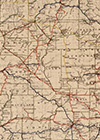
The Library of Congress has a historical map of Wisconsin’s Railroads that was originally published in 1900. Click or tap on the thumbnail to see it.
Passenger rail travel in Wisconsin peaked in 1917, when it is estimated that 98% of all visitors to northern Wisconsin traveled by train to reach their destinations. The slow, steady decline from this peak took several decades.
Riding the Trail
The northern segment of the trail, from Minocqua to Hazelhurst, passes through a drier, upland forest of tall maples, oaks, and occasional pines that often canopy the trail providing plenty of shade. Cottages, summer homes and resorts surround the Bearskin so there will be more people using this part of the trail, including bicyclists, walkers and joggers. There are two trestles in this stretch, both are just south of the Minocqua Trailhead.
The 9.3-mile section of the Bearskin Trail between Highway K and the South Blue Lake Rest Area features beautiful, intimate scenery and very little development. The Bearskin Creek meanders alongside the trail, and sometimes under. 11 trestles span the creek, its spring-fed tributaries and pools. Beautiful scenes of narrow waterways surrounded by cedars, tamaracks, spruce and pines occur throughout this stretch.
Interpretive signs are scattered along the northern half of the Bearskin Trail, detailing the rich history of the railroad and local flora and fauna.
The trail south of Highway K was officially added in 2016. This includes a 4.7-mile road-route surrounded by woods, open fields and a few rural homes and farms. The highlight of this segment is where the route rejoins the rail bed at Lake Nokomis Road and continues south into the heart of the resort area of Heafford Junction. This short stretch of the Bearskin is mostly used by those staying in the local resorts and cottages, who jump on the trail for a casual ride on the scenic causeway and trestles on Lake Nokomis, then pedal down to enjoy some ice cream at a popular ice cream shoppe next to the trail in Heafford Junction.
Trail Surface & Terrain
Most of the trail surface is compacted granite. Overall, the grade of the trail is generally flat except for one small hill named the ‘Pollnow Bypass’ near Bearskin Lake. A 4.7-mile road route runs from south of Highway K to Lake Nokomis Road.
Recommended Rides
A great out-&-back ride would be to park at the Highway K trailhead and ride north to the South Blue Lake Rest Area. The rest area has picnic tables, benches, grills, drinking water and vault toilets. Relax for a while under the cool shade of pines and birch on the west shore of a gorgeous northwoods lake. Then, when you’re ready, turn around and head back. This trip has 11 trestle crossings each way and is 18.6 miles total.
A shorter out-&-back ride that would include several of the most scenic trestles on the trail is from Highway K to the observation deck (11 miles total). This trip includes 9 trestle crossings each way.
Both rides feature some of the best intimate northwoods scenery the Bearskin Trail has to offer.
Trail Notes
Pets are allowed on the trail and must be kept on a leash shorter than 8 feet.
A Wisconsin State Trail pass is required for all individual bicyclists age 16 or older. Self-registration kiosks are available at the Minocqua and Highway K trailheads. No pass is required for walking or jogging on the trail (...including pets 😊).
Besides the parking area at Rantz, there are many ways to access the Bearskin between Minocqua and Hazelhurst including road crossings and short access paths connecting to local roads.
Be sure to bring plenty of water and snacks as there are few places selling food, snacks or beverages along the route. Outside of Minocqua there is a convenience store in Hazelhurst on Highway 51, and another at the intersection of Highway 51 and County Highway K. Drinking water is available at the South Blue Lake Rest Area. Heafford Junction, at the south end of the trail, has a popular ice cream shoppe that is well worth visiting.
Minocqua and the Surrounding Area
The north Trailhead in Minocqua lies close to the downtown area. One of the most popular tourism destinations in Northern Wisconsin, Minocqua features motels, cafés, restaurants, bars, popcorn and chocolate shoppes and several gift and souvenir shops. Two sporting goods stores with full-service bicycle shops are within a mile of the trailhead. Both offer bicycle sales, accessories, clothes, rentals and full-service repairs. A grocery store with deli sandwiches is about 0.6 miles north of the trailhead on Highway 51.
The surrounding region features hundreds of lakes and several beautiful lake chains. Perfect for fishing, boating, pontoon boating, jet-skiing, canoeing, kayaking and paddleboarding. For those who enjoy the ‘lake life’, there are many lakeside resorts, condos, restaurants and bars with public docks, so once you arrive you may never use your car, except to get groceries.
Minocqua sits at the edge of the sprawling Northern-Highland American Legion State Forest. The Forest features abundant outdoor recreational opportunities including, the Heart of Vilas County Paved Bike Trail (45+ miles), four mountain bike trail systems, and miles of nature trails and hiking trails. There over 900 lakes and 300 miles of rivers and streams. The Manitowish, Wisconsin and Trout Rivers and the Bittersweet Wild Lakes Area offer fun paddling adventures. Many rivers and lakes have dispersed, shoreline campsites so you could easily spend a couple of days or a week ‘roughing it’ in the outdoors.
The Nortern Highland-American Legion State Forest maintains four modern and 14 rustic family campgrounds totaling more than 800 campsites. Camping is incredibly popular in the NH-AL. Many of the sites are reservable and it is not unusual for entire campgrounds to be completely booked months in advance, especially on summer weekends and especially in July.
Facilities
- Minocqua: Parking, drinking water, restrooms, info kiosk, picnic area, shelter, lodging, restaurants, grocery, convenience stores/gas, bicycle shops, hospital/walk-in care (Woodruff)
- Rantz: Parking
- Hazelhurst: Parking, restaurant, convenience store, gas
- Highway 51: Parking, motel, restaurant
- South Blue Lake Rest Area: Drinking water (hand pump), shaded picnic area, picnic tables, grill, fire-pit, vault toilets.
- Goodnow: Parking
- Harshaw: Parking
- Highway K Rest Stop: Parking, drinking water (hand-pump), vault toilets, self-registration kiosk, shaded picnic area, picnic table, grill
- Heafford Junction: Parking, lodging, restaurants, ice cream shoppe
More Information
- Managing Agency: Wisconsin DNR
- Official Website: Bearskin State Trail
- Phone Contact: 715.539.2035
- Permit / Access Fee: Yes, WDNR State Trail Pass is required for bicyclists age 16 or older (Daily or Annual)
Nearby Recreation
Tomahawk River |
Scenic river paddling
Willow Flowage |
Scenic paddling, fishing, boating, remote camping
Northern Highland-American Legion State Forest | Camping, hiking, bicycling, mountain biking, canoeing, kayaking, boating, fishing, picnic areas