

Bois Brule River
(BB2) Bois Brule Landing to Pine Tree Landing, Wisconsin Trail Guide
Trail Facts
| Distance: | 10.3 miles |
| Skill Level: | Easy |
| Whitewater: | Class I |
| Approx. Paddle Time: | 4-5 hours |
| Elevation Drop: | 47 feet |
| Average Gradient: | 4.5 fpm |
Synopsis
Trail Review
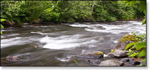
The stretch north of the US Highway 2 Bridge has three class 1 rapids but is mostly calm water. Much of this section features beautiful scenery as the river winds through a small valley. Occasional cabins, mostly along the right bank, do little to disrupt the tranquil experience.
The most notable feature of this section is an area known as 'The Meadows', which begins about three miles north of the US 2 Bridge. The surrounding landscape opens up into wide grasslands for a brief couple of miles. Wildlife is abundant, you will certainly see and hear many songbirds along the way including several species of warblers and thrush. Canoers and kayakers may occasionally spot a bald eagle scanning the river from atop a tall pine.
Canoe/Kayak Camping
The Bois Brule Campground is located at the putin for this segment (see BB1 for description and map) and the Copper Range Campground is located near the end. Both are part of the Brule River State Forest.
The Copper Range Campground is situated in an hardwood and mixed pine forest next to the river and offers a beach landing for paddlers. There are 15 rustic, family campsites that can accommodate tents and/or an RV up to 25-to-75 feet (max length varies). Each site has a picnic table and a fire ring. Amenities include drinking water and vault toilets. There are no electric hookups. Nine sites are reservable and six are available on a first-come, first-served basis.
46.610866, -91.581612
The location of the two campgrounds make multi-day excursions easy.
Season
The river is usually navigable throughout spring, summer and into fall. It can be scrappy in some places during periods of little rainfall in late summer and fall.
River Level Information
The river gauge referenced below is located in the previous segment (BB1) and should provide an accurate indication of current conditions in this reach.
River Gauge Location: Brule, WI
Suggested Minimum Level: 125 cfs / 1.4 feet
USGS Website: 04025500
Phone Contact for River Info: Brule River State Forest - 715.372.4866
Estimated Difficulty at Gauge Flow
| Below 125 cfs |
Paddling not recommended. |
| 125 cfs to 200 cfs |
Low runnable flow. Several riffles and rapids will be bony in this range. |
| 200 cfs to 350 cfs |
Medium runnable flow for novice paddlers. |
| 350 cfs to 600 cfs |
High runnable flow for novice paddlers. |
| 600 cfs to 1000 cfs |
Novice paddlers should avoid the river. |
| Above 1000 cfs |
Rare, high flows. Experienced paddlers only. Deadfall and strainers become quite hazardous when present, may be unavoidable at times! |