

Bois Brule River
(BB3) Pine Tree Landing to Highway 13, Wisconsin Trail Guide
Trail Facts
| Distance: | 8.4 miles |
| Skill Level: | Intermediate |
| Whitewater: | Class II-III |
| Approx. Paddle Time: | 3-4 hours |
| Elevation Drop: | 200 feet |
| Average Gradient: | 23.8 fpm |
Synopsis
Trail Review
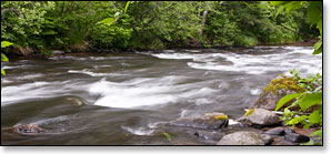
This segment of the Bois Brule features the most difficult whitewater of the river and should provide intermediate canoers and kayakers with plenty of exciting challenges. Paddlers will find rapids, rapids and more rapids seemingly non-stop for the first six miles or so. The highlights are class 2 Lenroot Ledges and class 2-3 Mays Ledges. Both are fairly long, medium hazard rips over a series of drops.
Lenroot Ledges can be fairly bumpy during lower flows so be sure to follow the main channel of flow, especialy where the river bends.
The river flows through a scenic, narrow winding valley, bordered by a lush forest of birch, poplar, ash, maple and mixed pine.
Be vigilant for deadfall! There are often strainers and submerged logs in some of the rapids!
Canoe/Kayak Camping
The Copper Range Campground (Brule River State Forest) is located near the end of the previous segment (BB2). The location of the campground can make segment BB3 the final leg of a two or three day paddle trip. Please see the previous segment's web pages for descriptions and maps of the two campgrounds on the Bois Brule.
Season
Water levels are usually adequate from spring through fall. Watch out for high levels during snow melt-off in spring.
River Level Information
The river gauge referenced below is located 10.5 miles upstream from this segment and should provide an accurate indication of current conditions in this reach.
River Gauge Location: Brule, WI
Suggested Minimum Level: 125 cfs / 1.4 feet
USGS Website: 04025500
Phone Contact for River Info: Brule River State Forest - 715.372.4866
Estimated Difficulty at Gauge Flow
| Below 125 cfs |
Paddling not recommended. |
| 125 cfs to 200 cfs |
Low runnable flow. Several rapids will be bony in this range. Scenic whitewater river trip for novice paddlers. |
| 200 cfs to 350 cfs |
Medium runnable flow for novice paddlers. Lenroot Ledges, and Mays Ledges are class II. Fun whitewater river trip for novice paddlers. |
| 350 cfs to 600 cfs |
High runnable flow for novice paddlers. Mays Ledges are class III at high end of this range. Some waves may scare or flip less-experienced paddlers. |
| 600 cfs to 1000 cfs |
Novice paddlers should avoid the river. BB1 and BB3 are intermediate runs. Fast current in constrictions. |
| Above 1000 cfs |
Rare, high flows. Experienced paddlers only. Ripping fast current in constrictions. Deadfall and strainers become quite hazardous when present, may be unavoidable at times! |