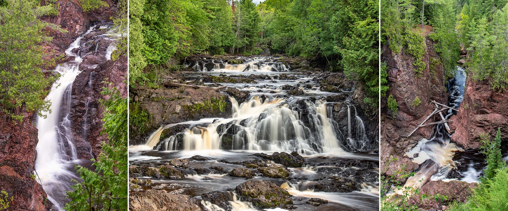
Gorge of the Bad River
The 3,000-acre Copper Falls State Park lies in northern Wisconsin, 25 miles south of Ashland near the town of Mellen. The highlight of the park is a dramatic, two mile-long gorge where the Bad River and the Tyler Forks River converge to form several scenic waterfalls. Copper Falls (29 feet) and Brownstone Falls (30 feet) are the park's signature waterfalls.
Other scenic highlights include include ‘The Cascades’ (Tyler Forks), Red Granite Falls (Bad River), and ‘Devil’s Gate’, a massive rock formation with abutments on both side of the Bad River. An uphill hike from the rim of the gorge leads to an observation tower with views of the forest covered hills of the Penokee Range to the north and Lake Superior in the far distance.
Work on the trail around the rim of the gorge began in the 1920's by returning veterans from World War 1, hence the trail's name, 'The Doughboy's Trail'. Later, the historic log building in the main picnic grounds, and most of the log fencing, footbridges, boardwalks, and stairways on the Doughboy’s Trail and CCC 692 Trail were constructed in the late 1930’s by the Civilian Conservation Corps and the Works Progress Administration. Today, these historic buildings, bridges, and fencing add a fantastic, rustic character to the park, and are a big reason why Copper Falls State Park is listed on the National Register of Historic Places.
Overall, Copper Falls State Park rates as one of the most beautiful destination parks in Wisconsin and is a favorite for families and couples.
Be sures to reward yourself with cool refreshments, hot sandwiches, and ice cream at the historic concession building after your hike.
The Doughboy's Trail
(loop)
Distance
Difficulty
Elevation Gain
& Packed Dirt
Trail Surface
The Doughboy's Trail loops around the Gorge of the Bad River and is the main attraction in the park. Doughboy’s is a scenic nature trail with observation decks and overlooks that provide fantastic views of the gorge including Copper Falls, Brownstone Falls, Devils Gate, and the Cascades. Signs along the trail detail the unique geologic history of the river, waterfalls, rock formations, and surrounding area.
Most of the trail runs along the rim through tall white pines and cedars and has limited views into the gorge. However, the unobstructed views from the observation decks and overlooks more than make up for the lack of visibility from the trail. The pine scented air and the constant roar of the falls add to the experience.
The trail is mostly flat and level except where it nears Devil's Gate, where flights of stone steps built into the hillsides on both sides of the Bad River lead down to a wide footbridge that spans the river.
It is recommended that you walk the Doughboy’s Trail loop in a clockwise direction. A relaxed stroll around the trail with stops at most of the scenic points can take up to two hours.
Pets are not allowed on the Doughboy's Trail!
Disabled Access
A half-mile segment of the Doughboy's Trail is graded for wheelchairs. Scenic features of this segment include the footbridge over the Tyler Forks River, an overlook of the gorge below Brownstone Falls, and views of Copper Falls from a footbridge on the east side of the gorge. The accessible trail has its own designated parking area.
CCC 692 Trail & Observation Tower
(point-2-point)
Distance
Difficulty
Elevation Gain
Stairway
Trail Surface
From the trailhead of the Doughboy’s Trail, you’ll cross a log footbridge over the Bad River and quickly come upon a rustic, wooden stairway leading uphill to your left. This is the start of the CCC 692 Trail that leads up to a 65-foot-high observation tower. There are 142 steps built into the hillside, plus a moderate incline to hike before you get to the base of the tower. The observation deck at the top of the wooden tower offers views of the forest covered hills to the north and Lake Superior in the far distance.
Continue on the CCC Trail past the tower, and you’ll be rewarded with a pleasant forest hike that descends along the ridges of steep-walled ravines and ends with a short walk along the Bad River below Devil’s Gate.
Pets are not allowed on the CCC 692 Trail!
Red Granite Falls
(loop)
Distance
Difficulty
Elevation Gain
& Packed Dirt
Trail Surface
Red Granite Falls is a stretch of scenic rapids and waterfalls that rushes over and around rocky ledges and massive boulders, all surrounded by pines, cedars and hardwoods. Though not as dramatic as the Gorge of the Bad River, Red Granite Falls offers beautiful scenery and is a worthwhile hike. There is no fencing along the river allowing you to scramble onto the ledges and boulders next to the rapids and falls (please exercise caution!). Up close, the power of the waterfalls is impressive, especially when river levels are medium or higher.
The Red Granite Falls Trail is a 2.5-mile lollipop loop over a wide gravel track (it's about 1.2 miles from the trailhead to the waterfall area).
Leashed pets are permitted on the Red Granite Falls Trail.
Other Trails
The Meadow Trail (1.5 miles) meanders around and through a large open field with plenty of songbirds and wildlife. Early morning hikes are very rewarding. The Takesson Trail (1.6 & 2.5 miles, double-loop) is open to hiking and mountain biking on a wide double track. The trail traverses hilly terrain through a mix of hardwoods and stands of mature pines. A beautiful, panoramic view of the Bad River from the top of a high ridge is a highlight of this trail. You may also hike or bike the scenic Vahtera Trails (1.2 & 1.7 miles, double loop) which features a scenic beaver pond surrounded by hemlocks on the inner loop. The outer loop passes through hardwood forest over hilly, glacial terrain.
Loon Lake
Loon Lake lies at the south end of the park, near the Headquarters Building and park entrance. This small, scenic lake is surrounded by a wooded shoreline with an area of spruce and tamarack bog on the south shore. The north shore features a sandy swimming beach and a grass lawn with tables and benches for picnicking or just relaxing in the sun. Kayaking and canoeing are fun activities and there are often great conditions for paddleboarding on less-windy days.
Picnic Grounds & Historic Log Building
The primary day use area is at the north end of Copper Falls Road in the center of the park . The trailheads for the Doughboy’s Trail, CCC 692 Trail, and access to the Observation Tower are located here. An expansive picnic grounds is shaded by tall pines and oaks and offers tables, grills and a children’s playground. A small nature center sits at the southeast corner of the parking lot.
An log building built in the 1930's by the CCC sits at the north end of the picnic grounds next to the Bad River, and the Doughboy's Trailhead. The west part of the building is a rustic shelter with tables, benches and a huge stone fireplace. The center of the building houses a concession stand serving beverages, hot food, sandwiches, ice cream, bagged ice, basic camping supplies, gifts and souvenirs. Inside is a world map where previous visitors have placed pins to mark where they're from. The concession stand is open every day during the summer and a popular pancake breakfast is served on Sunday mornings. Restrooms are in the east end of the building with running water and flush toilets.
A large open lawn, a softball field, and a sand volleyball court are across from the North Campground.
The North Country Trail*
A four-mile segment of the North Country National Scenic Trail meanders through Copper Falls State Park along its north-south axis. From the north, the trail joins the Doughboy’s Trail, crosses the Tyler Forks River above the Cascades, follows the east rim of the gorge, passes through the North Campground and finally, runs past Loon Lake.
If you’re on an extended hike on the North Country Trail, Copper Falls State Park is a great place to stop and camp for a day or two, rest your legs and soak up some gorgeous scenery. Groceries and basic supplies are available in Mellen at the grocery and hardware store, about a 40-minute hike from the State Park entrance.
North of the scenic gorge area is a 1.3-mile-long spur that leads to a backpack campsite in a beautiful setting next to the Bad River. The trail down to the site is easy to follow but is steep in several places. A camping permit is required (contact the Park Office).
46.38490, -90.63888
Pets Notice
'If you are bringing a pet to Copper Falls, please note that pets are not allowed on the Doughboys Nature Trail that goes to Copper and Brownstone Falls. There is no trail to view Copper and Brownstone Falls with your pet. Pets are permitted on the Red Granite Falls Trail, and Takesson and Vahtera Trails when they are not groomed for skiing. Please remember pets cannot be left unattended at any time while in the park, this includes in your vehicle or campsite.'
Source: Wisconsin DNR
Recreation & Attractions
Gorge of the Bad River, Tyler Forks River, Brownstone Falls (30 feet), Copper Falls (29 feet), Red Granite Falls, The Cascades, Devil’s Gate, hiking, interpretive trail, North Country Trail segment, historic POI, observation tower, picnicking, Loon Lake (swimming, paddle sports, fishing), tent & RV camping, backpack camping (North Country Trail), mountain bike trails (4.2 miles). Winter: groomed for cross-country skiing (22k classic, 7.4k skate)
Amenities
Staffed office (info, maps, rentals, accessible restrooms), parking, shelter, drinking water, accessible restrooms (running water, flush toilets), vault toilets, accessible trail, picnic grounds (shade, tables, grills), children's playground, pet play area (shade, tables, grills, river access), swimming beach, boat landing (non-motorized lake), campgrounds (electric sites, non-electric sites, group site, showers, dump station), firewood ($ fee), concessions (beverages, hot food, ice cream, souvenirs), rentals (kayaks, paddleboards), nature center, observation tower, ball field, sand volleyball court
Park Info
- Wisconsin DNR
- Copper Falls State Park
- 36764 Copper Falls Road
- Mellen, WI 54546
- Phone: 715.274.5123
- Official Website: Copper Falls State Park
- Permit / Access Fee: Yes, WDNR Vehicle Admission Sticker Required (Daily or Annual)
- Park Hours: Open 6:00am to 11:00pm year-round
- Headquarters GPS: 46.353132, -90.645658
Local Trails & Places
- Potato River Falls* | Waterfalls, scenic gorge
- Wren Falls* | Waterfalls, rock formations
- Foster Falls* | Waterfalls, rock formations
- Morgan Falls-St Peters Dome* | Waterfalls, scenic overlook
- Corrigan's Lookout* | Scenic overlook
- White River | Paddling