A Beautiful Riverside Trail
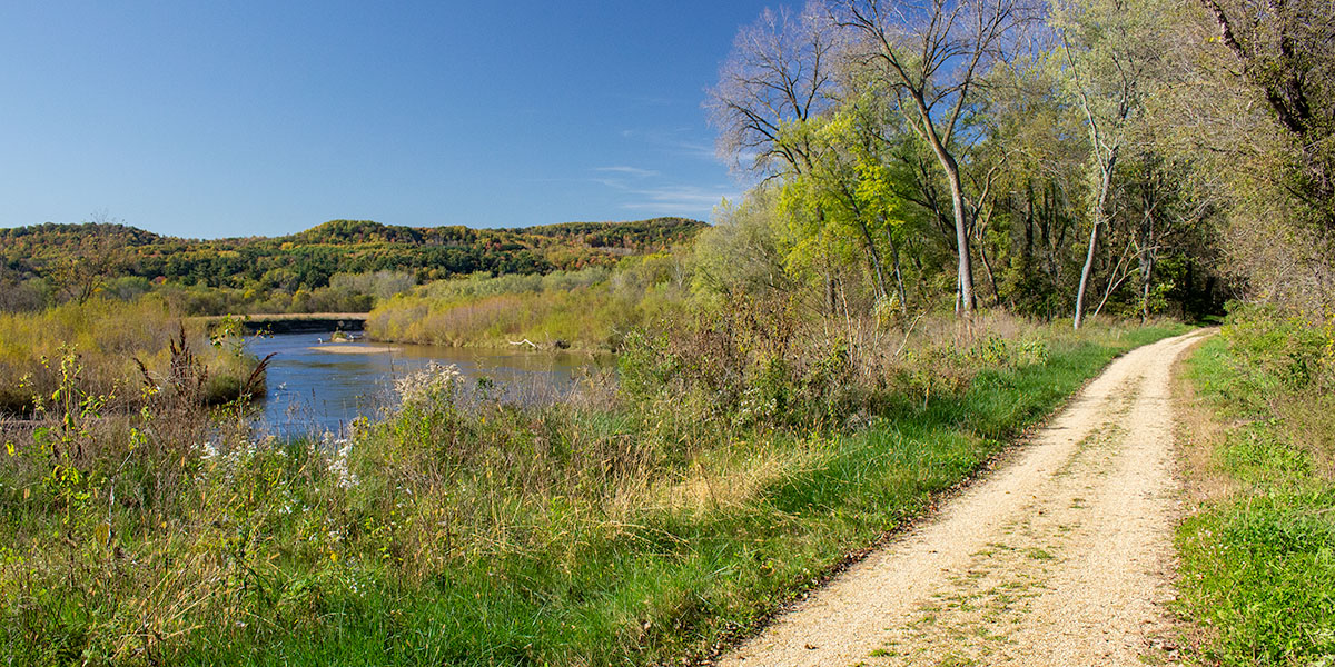
One of Wisconsin's first rail-trails, The Red Cedar offers a pleasant ride through a rural countryside along its scenic namesake, the Red Cedar River. The north trailhead is at the Menomonie Depot and Visitor Center in Menomonie and runs south for 15 miles to the junction with the Chippewa River State Trail. Bicyclists, walkers and joggers will find scenic river views, rock formations, railroad trestles, and historical sites. The grade of the entire trail is flat, making this a fun and easy ride for everyone from “seasoned citizens” to families with children.
Oak, maple, birch, elm, aspen and mixed-pines and often shade the trail. Thick patches of ferns are often found wherever there’s shade. Several different species of wildflowers grow along the trail. Occasionally the trail passes corn fields and open prairie. Look past the fields and you’ll have views of unglaciated hills in the distance where hardwood forests cover the steep hillsides.
If you’re riding in the morning or late afternoon, you’ll likely see an abundance of wildlife including white-tailed deer, raccoons, squirrels, chipmunks, and many different species of birds. Wherever there are open fields you’ll hear crickets chirping away.
There are frequent unobstructed views of the Red Cedar River which often flows within a few feet of the trail. Several small trestles cross sandy-bottomed creeks and The Red Cedar Trestle, just north of Downsville, is a scenic highlight. Another highlight is a tiny waterfall about one mile north of Highway Y. If you’re doing an out-&-back from Menomonie, this is a nice location to stop, rest, and turn around.
Point-2-Point
Total Distance
Moderate
Difficulty
Grade
Granite
Trail Surface
Trail Surface & Terrain
Most of the trail is hard-packed, crushed stone. The surface is so hard on most of the trail that it will feel like you're riding on paved trail with a few bumps here and there. Long stretches are straight and flat. Hills and steep gradients are absent.
History of the Trail
The former rail line was used to transport stone from local quarries that operated in the area from 1880 through the 1950’s. Today, visitors will find two historical sites along the trail south of Downsville that detail some of the work that went on here. One site is named the ‘Downsville Cut’ and features a 40-foot high wooden derrick that was used to load cut stones onto railroad cars. A little farther south, another site features a pile of cut stones stacked to form a small arch. A nearby kiosk displays pictures and articles about some of the history of the local area.
Historical Notes
By the mid 1870’s, Menomonie’s principal lumber company, Knapp, Stout & Co. was the largest lumber corporation in the world. It produced over 5.7 million board-feet of lumber annually and directly employed more than 1,200 people. The boom was short-lived, however. The company ceased operations in 1901 as the local region was gradually logged out.
The Library of Congress has a historical map of Wisconsin’s Railroads that was originally published in 1900. Click or tap on the thumbnail to see it.
Riding the Trail
Menomonie Trailhead
The old train depot in Menomonie serves as the Visitor Center and north trailhead for the Red Cedar State Trail. The indoor visitor center is staffed during seasonal hours (May through October) and offers trail information, trail passes, an exhibit area and restrooms. Next to the depot building are a gazebo, shaded picnic area, an information kiosk with paper trail maps and a notice board which displays general rules for the trail, the cost of trail passes and how to self-register at the kiosk when the visitor center is closed. Keep your pass with you when you ride. A large trail map sign sits at the trailhead.
Riverside Park in Menomonie
Riverside Park sits between the Menomonie Depot and the Red Cedar River. The park features a large shaded lawn with picnic tables, BBQ grills, a children’s play area, restrooms with running water and a drinking fountain. Use the restrooms here when the visitor center is closed.
Gilbert Creek
At 0.25-miles south of trailhead, the trail crosses a short trestle over a small, narrow gorge. A clear, sand-bottomed creek flows beneath the bridge and into the Red Cedar.
Please ride slow in the two mile stretch south of Menomonie. There are frequent walkers and joggers on the northern part of the trail.
1-Mile marker
In the two-mile stretch south of Menomonie, the river is almost always within sight. The riverbed is rocky and at normal levels you’ll often hear the river as it rushes through riffles and minor rapids. A thin screen of trees runs between the trail and the river with frequent openings offering views of high wooded banks on the opposite shore. Wildflowers often surround the trail. Scenic sandstone rock formations are located south of the 1-mile marker.
Irvington
Irvington features a paved parking area, a shaded picnic table, a bike rack and a trail-map sign. The trail is paved where it passes under the Highway D bridge.
At the 3-mile marker, the trail crosses a trestle over a narrow creek. The short wooden bridge offers scenic views of the river. South of the trestle, the trail runs through a narrow corridor with sandstone cliffs on one side and the river on the other. You may notice a drop in the air temperature when you’re riding pass the high sandstone walls.
4-, 5-, and 6-Mile Markers
Forest surrounds the trail where it wanders away from the river. The ground tends to be sandy and the trees often arch overhead to shade the trail and large patches of ferns. Where the trail passes corn fields or prairie, you’ll see the steep-sided hills of Wisconsin’s driftless region, usually to the west. One of these is named ‘The Pinnacle’, near the 4-mile marker. Birdlife in this area is abundant.
The Red Cedar Trestle
The trail crosses a steel-beamed trestle over the Red Cedar with excellent views of the river. South of the bridge, the trail runs east of the river all the way to the junction with the Chippewa River State Trail.
Downsville
The trail access has a paved parking area, drinking water, restrooms with running water, a picnic table, a self-registration kiosk with a trail map and a box of paper maps. Downsville has a convenience store, restaurants, a coffee shop, historical museum and lodging.
8- and 9-Mile Markers
South of Downsville, the river is often out of sight. Oak, elm, birch and aspen shade the trail along with occasional maples and pines. Beautiful, wooded hills are visible where the trail passes agricultural fields. This is another scenic stretch.
Downsville Cut & “The Spar”
A short spur leads to the Downsville Cut historical site where ‘The Spar’, a 40-foot-high derrick stands surrounded by forest. This is where sandstone from a local quarry was loaded onto railroad cars. Quarries in the area operated from the 1880’s to the 1950’s.
The surrounding landscape is more wooded and noticeably hillier south of ‘The Spar’. Red and white pines become more common. The river passes through bottomland forest and is occasionally close to the trail.
11-Mile Marker
The trail’s southern-most picnic area sits in a clearing with views of the river near the 11-mile marker. Here, the river flows past sandy banks and bottomland forest in a narrow valley. Steep, forested hills surround the valley and the trail. Look up and you may see a bald eagle gliding over the river searching for its next meal . If you’re fortunate enough to see an eagle up close, you’ll begin to appreciate how big they are. This is a very scenic spot.
An historical site is located south of the picnic area, on the east side of the trail. Several large cut stones are stacked in an arch formation next to a display with old photos and newspaper clippings detailing the history of quarrying in the area.
South of the 11-mile marker is a tiny waterfall that trickles over a small rock formation. West of the trail, opposite the waterfall, an opening in the foliage provides a clear view of the river. There are a pair of benches to relax and take in the peaceful setting.
Highway Y, Dunnville Boat Landing
The trail access is east of the Highway Y bridge. Trail users may park in the Dunnville Boat Landing’s large paved parking area west of the bridge. Parking is free. The bridge has a wide bike lane for cyclists to cross safely. There are no facilities at the boat landing.
Highway Y to the Chippewa State Trail
The trail continues south from Highway Y for two miles through the dry and sandy Dunnville Wildlife Area. The trail crosses a long trestle over the Chippewa River at the south end of the Wildlife Area. Sandbars often form, especially in mid to late summer, and locals will come and relax on the sandy beaches and wade in the shallow waters on weekends (be careful of drop offs in the lee of the sandbars). The scenery here is beautiful.
The Red Cedar State Trail ends south of the Chippewa River where it intersects with the Chippewa River State Trail, another Wisconsin rail-trail. Please be sure to have plenty of drinking water when riding through this area.
Trail Notes
Pets are allowed on the trail and must be kept on a leash shorter than 8 feet.
A Wisconsin State Trail pass is required for all individual bicyclists age 16 or older. Self-registration kiosks are available at the Menomonie Depot and Downsville. No pass is required for walking or jogging on the trail (...or pets 😊).
Be sure to bring plenty of water and snacks as there are very few places selling food, snacks or refreshments along the trail. Outside of Menomonie there is a convenience store and restaurants in Downsville, and thats it.
Facilities
- Menomonie: Menomonie Depot Visitor Center, parking, drinking water, restrooms, info kiosk, picnic area, shelter, souvenirs, lodging, restaurants, grocery, Hospital/Walk-in Care
- Irvington: Parking
- Downsville: Parking, drinking water, restrooms (summer only), restaurants
- Dunnville: Parking
- Dunnville State Wildlife Area: Parking (no shade)
Trail Management
The Chippewa Valley Trail System is managed by the Wisconsin DNR and includes three interconnecting trails totaling 83 miles, the Old Abe State Trail, the Chippewa River State Trail and the Red Cedar State Trail. The trails connect Cornell, Chippewa Falls, Eau Claire, Menomonie and several smaller communities.
More Information
- Managing Agency: Wisconsin DNR
- Official Website: Red Cedar State Trail
- Phone Contact: 715.232.1242
- Permit / Access Fee: Yes, WDNR State Trail Pass is required for bicyclists age 16 or older (Daily or Annual)
Nearby Recreation
Chippewa River State Trail | Bicycle path, 30 miles
Old Abe State Trail | Paved bicycle path, 37 miles
Lowes Creek | Mountain bike trails
Chippewa River | Paddle river
Red Cedar River | Paddle River