

St Croix River
(SC3) Riverside Landing to Thayer's Landing, Wisconsin Trail Guide
Trail Facts
| Distance: | 13.4 miles |
| Skill Level: | Easy |
| Whitewater: | Class I-II |
| Approx. Paddle Time: | 6 hours |
| Elevation Drop: | 15 feet |
| Average Gradient: | 1.1 fpm |
Synopsis
Trail Review
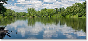
This is a wonderfully scenic segement of the St Croix. The river runs wide and slow through a lush forest of mixed northern hardwoods and conifers. Densely wooded rolling hills often border the river and paddlers will find numerous, wooded islands with narrow channels that can be fun to explore. The majority of this section is flatwater with one named rapids at State Line Rapids (class I-II), located a little more than two miles below the Highway 35 Bridge.
Three rivers join the St Croix in this stretch; the Upper and Lower Tamarack Rivers and the Yellow River. The additional flow widens the St Croix considerably above Thayer's Landing.
Riverside Landing is a popular takeout for paddlers finishing single and multi-day trips on the upper St Croix and the Namekagon River.
Canoe/Kayak Camping
The National Park Service has two individual and two group campsites in this segment. Individual sites accommodate up to three tents and/or eight people, while the group sites hold up to six tents and/or sixteen people. There are no fees for accessing, camping, or parking in any of the National Scenic Riverway areas. There is a three night limit of stay. All sites are on a first-come, first-served basis. No glass beverage containers are allowed on the riverway!
Season
This segment is usually navigable throughout the warm-weather season.
River Level Information
On the Web: St Croix National Scenic Riverway website
Phone Contact: NPS Namekagon Visitor Center, 715.635.8346