

Namekagon River
(N2) Hayward Landing to Springbrook Landing, Wisconsin Trail Guide
Trail Facts
| Distance: | 16.2 miles |
| Skill Level: | Novice |
| Whitewater: | Riffles |
| Approx. Paddle Time: | 8 hours / multi-day |
| Elevation Drop: | 95 feet |
| Average Gradient: | 5.8 fpm |
Synopsis
Trail Review
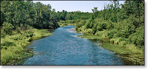
With the large number of easily accessible landings, this segment can be broken into smaller trips. However, there is also a large number of canoe/kayak campsites which make this stretch very popular for multi-day excursions. The run features long stretches of flatwater with intermittent pitches of low hazard rapids that should pose no problems for most novice paddlers who possess some maneuvering skills. The river continues to run within the protective confines of the St Croix National Scenic Riverway.
As you paddle south from Hayward, the homes and businesses quickly disappear within a half mile. By the time you approach Warder Rapids, an easy class 1-2 a mile south of Hayward, you'll be paddling through beautiful northern forest and bog. The river meanders past scenic stands of hardwoods and mixed pine, occasionally forking around small grassy islands.
Another stretch of riffles and easy class 1 rapids occurs at Fox Slough. Then the river enters an area of frequent open marsh, a number of sloughs and several streams enter the main waterway which forks around numerous islands. The forest close in again briefly before another, longer stretch of open wetlands where you'll paddle past more stream outlets and islands.
After Stinnett Landing, the surrounding landscape becomes drier, the sandy riverbanks are high and steep, and a beautiful northwoods forest of mixed hardwoods and conifers cozy up to the river. Riffles and light rapids occur more often over the next several miles. Chippanazie Rapids begin just past the Brickman Lake Road Bridge. The rapids rate between class 1 and 2 and run past several wooded islands. Downstream, the river continues to flow past steep sandy banks and rolling hills all the way to Springbrook Landing.
Even though the lower half of this section runs close to Highway 63, it is still a wonderfully scenic trip and very much worthwhile!
Camping
Canoe/Kayak Camping
The National Park Service has five individual and seven group campsites in this segment. Individual sites accommodate up to three tents and/or eight people, while the group sites hold up to six tents and/or sixteen people. There are no fees for accessing, camping, or parking in any of the National Scenic Riverway areas. There is a three night limit of stay. All sites are available on a first-come, first-served basis. No glass beverage containers are allowed on the riverway!
Chequamegon-Nicolet National Forest Campgrounds
The Chequamegon-Nicolet National Forest has three campgrounds within a 45 minute drive of this segment. All three offer online reservations; Namekagon (34 sites) and Two Lakes (94 sites) are the closest. Both are popular campgrounds located on scenic lakes with plenty of shady, secluded sites.
The third campground with reservable sites is at Moose Lake (15 sites). Not as popular as the previous two, but this one offers more seclusion and is situated next to a beautiful northwoods lake.
Season
This segment is usually navigable throughout the warm-weather season.
River Level Information
River levels are monitored by the National Park Service with frequent status updates on the webpage linked to below.
NPS Website: St Croix and Namekagon River Levels
Phone Contact for River Info: NPS, Namekagon River Visitor Center: 715.635.8346