

Namekagon River
(N4) County K Landing to Fritz Landing, Wisconsin Trail Guide
Trail Facts
| Distance: | 17.5 miles |
| Skill Level: | Easy |
| Whitewater: | Class I |
| Approx. Paddle Time: | 8 hours / multi-day |
| Elevation Drop: | 64 feet |
| Average Gradient: | 3.7 fpm |
Synopsis
Trail Review
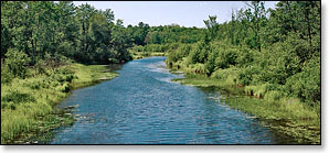
From County K Landing the river flows into a remote wilderness setting where canoers and kayakers will see almost no development. The river is mainly flatwater with only a few brief periods of riffles and light rapids. A lush, dense forest often canopies the riverbanks. Hardwoods are dominant and include stands of aspen, birch, ash, box-elder, and maple. Mixed pine along with cedar and spruce are also common. Rolling hills and high sandy banks often surround the river, occasionally interrupted by open, grassy marsh. Wildlife is abundant.
Numerous islands fork the river, often occurring where the river bends into small oxbows. The small channels can be fun to explore but be aware of overhanging trees that create strainers.
For single day trips, the 9.9 mile reach between County K and Whispering Pine Landing is one of the most recommended paddles by the National Park Service Rangers. This stretch is beautiful and secluded.
Camping
Canoe/Kayak Camping
Canoe/kayak camping excursions are incredibly popular in the thirty mile reach from the County K Landing on the Namekagon to the Riverside Landing on the St Croix. The National Park Service has thirty-eight canoe campsites in this stretch which includes segments N4 and N5. Fourteen occur in this segment (N4), ten individual and four group sites. The group camps at Howell and West Howell Landings are vehicle accessible. Water is available at Howell Landing (June through September).
Individual sites accommodate up to three tents and/or eight people, while the group sites hold up to six tents and/or sixteen people. There are no fees for accessing, camping, or parking in any of the National Scenic Riverway areas. There is a three night limit of stay. All sites are available on a first-come, first-served basis. No glass beverage containers are allowed on the riverway!
Minnesota State Park Campgrounds
Minnesota's St Croix State Park is about a 40 minute drive west of Fritz Landing on Highway 77. This is Minnesota's largest state park and features more than 200 miles of hiking, biking and horse trails.
A concession building "offers canoe rentals, shuttle service and sells groceries, ice, camping supplies and convenience items as well as Nature Store items that include t-shirts, caps, gifts. Open daily Memorial Day through Labor Day and on weekends only from May 1 to Memorial Day and Labor Day through Oct. 1."
The Visitor Center lodge "is located in the vicinity of the campgrounds. The building is a historic log and stone building that includes flush toilets available year-round and a public shelter area with fireplace and seating for indoor programs. Building overlooks the St. Croix River."
_Source: MNDNR
The St Croix State Park has three campgrounds with a total of: 211 drive-in sites, 2 backpack sites, 4 walk-in sites and 7 canoe/kayak campsites on the St Croix River. Firewood is available year-round.
Season
This segment is usually navigable throughout the warm-weather season.
River Level Information
River levels are monitored by the National Park Service with frequent status updates on the webpage linked to below.
NPS Website: St Croix and Namekagon River Levels
Phone Contact for River Info: NPS, Namekagon River Visitor Center: 715.635.8346