

Namekagon River
(N1) Namekagon Dam Landing to Cable Wayside Landing, Wisconsin Trail Guide
Trail Facts
| Distance: | 13.5 miles |
| Skill Level: | Easy |
| Whitewater: | Class I |
| Approx. Paddle Time: | 5-6 hours |
| Elevation Drop: | 134 feet |
| Average Gradient: | 9.9 fpm |
Synopsis
Trail Review
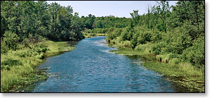
From the Namekagon Dam Landing, the narrow river quietly meanders through low banks of fen forest and open marsh for the first several miles. The first rapids occur a little more than two miles below the dam where the surrounding forest closes in and the river rushes through a long pitch of class 1 rapids. After the rapids, the river slows and widens and the forest recedes into the distance as open marsh once again claims the riverbanks.
This pattern continues for the entire section, slow and calm with occasional riffles through open marsh, then the river constricts and rushes through a low hazard rapids between densely wooded banks.
There is plenty of wildlife along the upper Namekagon, especially beaver. These little furballs love building dams and it's quite amazing to see what they're sometimes able to accomplish. Occasionally their dams get pretty big, and one may be blocking the river channel requiring paddlers to make a short portage. So plan on getting your feet wet! Please do not do anything to disturb the dams, you're the visitors out here.
Camping
Canoe/Kayak Camping
The National Park Service has one individual campsite in this segment, located about 1.5 miles above the takeout at Cable Wayside landing. Individual sites accommodate up to three tents and/or eight people. There are no fees for accessing, camping, or parking in any of the National Scenic Riverway areas. There is a three night limit of stay. All sites are available on a first-come, first-served basis. No glass beverage containers are allowed on the riverway!
Wisconsin State Park Campgrounds
Copper Falls State Park is about a 45 minute drive northeast from the Namekagon Dam Landing. The family campground offers 56 secluded campsites and a group camp for tent camping (up to 40 people). This is the most scenic gorge and waterfall area in Wisconsin and the Doughboys Trail is featured in this guide.
“Ancient lava flows, deep gorges and spectacular waterfalls make Copper Falls one of Wisconsin's most scenic parks. Log buildings built by the Civilian Conservation Corps in the 1930s add to the park's charm. There is plenty to do; hiking, bicycling, picnicking, fishing and swimming. The North Country National Scenic Trail passes through Copper Falls State Park.”
_source: Wisconsin DNR.
Chequamegon-Nicolet National Forest Campgrounds
The Chequamegon-Nicolet National Forest has eight campgrounds within a 40 minute drive of this segment. Seven of the eight campgrounds offer online reservations; Namekagon (34 sites) and Two Lakes (94 sites) are the closest. Both are popular campgrounds located on scenic lakes with plenty of shady, secluded sites.
The five other campgrounds with reservable sites are: Day Lake (52 sites), East Twin (10 sites), Mineral Lake (11 sites), Beaver Lake (10 sites) and Lake Three (8 sites). All of these campgrounds are also located on scenic northwoods lakes. Perch Lake, another popular family favorite, does not offer reservations at this time.
Season
The best paddling is usually in May and June, thereafter following an extended rainfall from July through September. This segment is often navigable into late fall, but you may have to walk through some shallow riffles and rocky rapids.
River Level Information
River levels are monitored by the National Park Service with frequent status updates on the webpage linked to below.
NPS Website: St Croix and Namekagon River Levels
Phone Contact for River Info: NPS, Namekagon River Visitor Center: 715.635.8346