

Eau Claire River
(EC1) Bear Lake Road to County N Bridge, Wisconsin Trail Guide
Trail Facts
| Distance: | 14.2 miles |
| Skill Level: | Novice (Advanced) |
| Whitewater: | Class II-III (IV) |
| Approx. Paddle Time: | 6-8 hours |
| Elevation Drop: | 168 feet |
| Average Gradient: | 12.0 fpm |
Synopsis
Trail Review
This reach of the Eau Claire River is one of the best class II-III whitewater river-runs in Wisconsin. Unfortunately, water levels are normally too shallow for enjoyable paddling in the lower half of this segment during most of the summer. But when the conditions are right, the four-mile stretch from the Eau Claire Dells through the Lower Island Dells are a wavy thrill-ride for whitewater enthusiasts who are expanding their skillset.
Advanced level kayakers will enjoy the short run of The Ledges and the Eau Claire Dells. The Ledges features numerous class III waves and holes in medium to high flows while the EC Dells offers up a challenging class IV waterfall and rapids through a scenic, rocky gorge. Both of these features are located in the middle of this segment and can easily be portaged by less-skilled paddlers.
Other noteable rapids include: Master Ledges (class II), Three Rows Falls (class II), and a pair of thrilling class II-III's below the Eau Claire Dells named: Upper Island Dells and Lower Island Dells. Both are long, fast and narrow rips when water conditions are medium to high with multiple channels and beautiful scenery.
Those who run the Eau Claire Dells will usually, only run the Dells, putting in just above the dam (when the gates are open) and taking out just below the falls. Most paddlers who run the entire segment will portage the The Ledges and the Eau Claire Dells altogether, taking out above the dam and hiking along the wide footpath to below the falls. Just be aware, there is a short series of steep steps you'll have to navigate near the end of the portage.
On those occasions during the summer when the river is running, local whitewater paddlers will often make the 'short run' from just below the the Eau Claire Dells to the County N Bridge Landing, though some will take out at County Z. To reach the put-in, park in the Eau Claire Dells County Park at the south parking lot (south of the County Y Bridge) and hike down the trail about 120 yards to reach the river below the Dells Rapids (and a small island). This makes for an enjoyable six-mile whitewater trip with the takeout at the County N Bridge.
Most of this segment meanders through mixed hardwood and pine forests surrounded by a quiet agricultural countryside. Maple, birch, cedar, hemlock, red and white pine often canopy dense undergrowth along the river banks. Thick patches of canada yew populate the Dells; the spring bloom is beautiful!
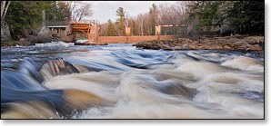
Scenic rock formations abound in the lower portion of this segment, starting with the Eau Claire Dells.
Camping
Canoe/Kayak Camping
The Dells of the Eau Claire County Park has an excellent family campground with 28 campsites, 16 with electricity. The campground offers easy river access above the Dells Rapids, just above the dam. Campsites are available on a first-come, first-served basis. The County Park is one of the most scenic in Wisconsin with several hiking trails along the river and numerous overlooks at the Dells. The County Park sits in the middle of this segment, so you can easily stretch out your paddle-trip into two fun days of paddling and hiking.
Wisconsin State Park Campgrounds
Council Grounds State Park offers a family campground along the shores of the Wisconsin River near Merrill. There are 55 campsites in an heavily wooded area with showers and flush toilets. 19 sites have electricity. There are 3 group sites with electricity that hold 32 people each.
Chequamegon-Nicolet National Forest Campgrounds
The Chequamegon-Nicolet National Forest has an excellent campground about 45 miles driving distance northeast of the Eau Claire River in the southeast corner of the Laona-Lakewood District. The beautiful and popular Boulder Lake Campground has 89 family-sites and 10 group sites; many of which are reservable. Boulder Lake Campground lies less than 2 miles from the Wolf River near Markton.
Season
For Advanced level kayakers, the best paddling for the Eau Claire Dells is in the spring during the snow melt-off, or after a sustained rainfall during the rest of the warm-weather season.
For the rest of the segment, paddling conditions vary quite a bit throughout summer and fall, mostly dependant on rainfall. In low water conditions, the riffles and rapids can become to shallow to paddle through, especially in the lower half of this segment. Most paddlers should avoid the river at high water levels!
River Level Information
Phone Contact for River Info: N/A
USGS Website: USGs Gauge @ Kelly, Hwy SS Bridge
National Weather Service Flood Stage: 4,000 cfs / 9 feet
Please note: Water levels on the Eau Claire River can rise and fall rapidly during the warm-weather season, sometimes by more than a foot in gauge height in just a few hours. In addition, the river gauge is 11 miles downstream from the end of this segment. So the readings can sometimes be misleading. Pay attention to how the gauge is trending (rising or falling) and plan accordingly. Particularly during the summer, watch the weather reports and the radar. If a big weather system rolls through then the river will maintain consistent levels for several days and the gauge readings will be fairly accurate. If a smaller system passes through, then the levels will spike more dramatically and the gauge readings will be less accurate. Levels in the 3 Dells sections can be off by as much as 500 cfs in comparative readings depending on circumstances.
Scout the rapids and know your limitations!
Estimated Difficulty at Gauge Flow
| Below 300 cfs |
Paddling not recommended. |
| 300 cfs to 600 cfs |
Novice Paddlers: Scenic, low-hazard whitewater river trip. Rapids below the Dells will be bony in this range, you may have to step out and push in places. Advanced Paddlers (Eau Claire Dells): The 'Left Main' drop at Eau Claire Dells is runnable (class 3), but not overly exciting. |
| 600 cfs to 1000 cfs |
Novice Paddlers: Low runnable flow, scenic whitewater river trip. All rapids below the Eau Claire Dells should be runnable in this range, including the left fork of the Upper Island Dells. Portage the Eau Claire Dells. Advanced Paddlers (Eau Claire Dells): The Ledges are a wavy class II. The 'Left Main' drop at Eau Claire Dells is likely a boofing drop in this range with a sticky release. |
| 1000 cfs to 1500 cfs |
Novice Paddlers: Medium runnable flow, excellent and challenging whitewater river trip, Upper Island Dells & Lower Island Dells are wavy, solid class II. Portage the Eau Claire Dells. Advanced Paddlers (Eau Claire Dells): The Ledges are class II wave-trains. The 'Left Main' drop at Eau Claire Dells may still be boofing in this range. ‘Middle Chute’ is starting to form. Pushy current in tight confines, sticky holes and eddies. |
| 1500 cfs to 2000 cfs |
Novice Paddlers: High runnable flow for novice-whitewater paddlers, challenging whitewater river trip, Upper Island Dells are class II+, Lower Island Dells are approaching class III. Occasional, pushy waves over 2 feet high may scare or flip less-experienced paddlers. Fast current, watch for ‘stealth-boulders’. Portage the Eau Claire Dells. Advanced Paddlers (Eau Claire Dells): The Ledges are wavy class III. The 'Left Main' drop at Eau Claire Dells has powerfull hydraulics in tight confines. 'Middle Chute' is nice boofing drop at high end of this range! 'Right Sneak' should be starting to form. |
| 2000 cfs to 2800 cfs |
Novice Paddlers: Avoid the river. Powerful hydraulics will overpower less-experienced paddlers, especially at Upper Island Dells and Lower Island Dells, which are both class III in this range. Intermediate Paddlers: Should be a challenging class III+ run from the base of the Eau Claire Dells to Badger Road. Lower Island Dells are approaching class IV at high end of this range. Advanced Paddlers (Eau Claire Dells): Spring meltoff conditions, The Ledges are class III+. Eau Claire Dells are approaching class IV at high end of this range - the current is very fast and powerful in the rapids. 'Middle Chute' and 'Right Sneak' should be runnable by 2000(?) cfs. |
| 2800 cfs to 3400 cfs |
Novice and Intermediate Paddlers: Avoid the river. Advanced/Expert Paddlers: Overall the river-hydraulics are big and powerful. Very sticky class IV holes in The Ledges - ‘heavy’ and ponderous water. The Eau Claire Dells are running full blast, bank-to-bank, a class V powerhouse. Upper Island Dells are class III+, Lower Island Dells are class IV with low margin for error. You could easily raft all three Dells sections in this range. |
| Above 3400 cfs |
Experts only! The Ledges and Lower Island Dells are class IV+, Eau Claire Dells are class V. Downed trees and debris pileups in Lower Island Dells are very hazardous when present. |