

Chippewa River
(C3) County A Bridge to Highway 8, Wisconsin Trail Guide
Trail Facts
| Distance: | 9.0 miles |
| Skill Level: | Easy |
| Whitewater: | Riffles |
| Approx. Paddle Time: | 4 hours |
| Elevation Drop: | 20 feet |
| Average Gradient: | 2.2 fpm |
Synopsis
Trail Review
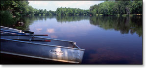
Novice and flatwater canoers and kayakers will enjoy this quiet and peaceful, scenic stretch which has only a few light riffles and wide-spaced boulder gardens. Hardwood forests, dense undergrowth and frequent tall grasses dominate the riverbanks with an occasional farm or home along the river.
The river is usually runnable from early spring through late fall. Novice paddlers need to exercise extra caution when the waters levels are high. High flows generally occur through early May, after periods of heavy rainfall, and when the Arpin Dam has a release. This is an excellent river to paddle in late summer and fall when many other rivers are experiencing low water volume. Contact the Wisconsin DNR office in Ladysmith (see below) for water levels before paddling the river.
Season
The river is usually runnable from early spring through late fall. Novice paddlers need to exercise extra caution when the waters levels are high. High flows generally occur through early May, after periods of heavy rainfall, and when the Arpin Dam has a release. This is an excellent river to paddle in late summer and fall when many other rivers are experiencing low water volume. Contact the Wisconsin DNR office in Ladysmith (see below) for water levels before paddling the river.
River Level Information
River Gauge Location: Bruce, WI
Suggested Minimum Level: 1.5 feet / 400 cfs
USGS Website: USGS Gauge @ Bruce
Phone Contact for River Info: WDNR Office @ Ladysmith; 715.532.3911