

Chippewa River
(C1) Arpin Dam to County D Bridge, Wisconsin Trail Guide
Trail Facts
| Distance: | 9.4 miles |
| Skill Level: | Novice (Interm.) |
| Whitewater: | Riffles (Class II-III) |
| Approx. Paddle Time: | 3-4 hours |
| Elevation Drop: | 69 feet |
| Average Gradient: | 7.3 fpm |
Synopsis
Trail Review
This section is mostly flatwater except for Bellile Falls, which are located at the beginning, just below Arpin Dam. The condition of the falls depends solely on an Arpin Dam release. When this happens the falls become a frothy, class 3 behemoth -total joy for the intermediate to advanced level whitewater crazies. The waves can get pushy though. During low water conditions, the falls are shallow and scrappy and probably not worth the effort. Most paddlers avoid the falls and use the landing a few hundred yards to the south off of River Drive.
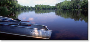
Below Bellile Falls, the river provides a peacefull, flatwater run with a few sets of riffles. There are several beautiful wooded islands in this section as the river passes through forests of maple, birch and basswood. Beautiful grassy meadows occasionally border the river and paddlers will be greeted by abundant bird life throughout this segment. There are few signs of development along the river.
Season
The river is usually runnable from early spring through late fall. Novice paddlers need to exercise extra caution when the waters levels are high. High flows generally occur through early May, after periods of heavy rainfall, and when the Arpin Dam has a release. This is an excellent river to paddle in late summer and fall when many other rivers are experiencing low water volume. Contact the Wisconsin DNR office in Ladysmith (see below) for water levels before paddling the river.
River Level Information
River Gauge Location: Bruce, WI
Suggested Minimum Level: Bellile Falls: 1400 cfs (estimate!)
Suggested Minimum Level: Below Bellile Falls: 400 cfs / 1.5 feet
USGS Website: USGS Gauge @ Bruce
Phone Contact for River Info: WDNR Office @ Ladysmith; 715.532.3911