

Brule River
(B2) Highway 139/189 Bridge to Forest Road 2150, Wisconsin Trail Guide
Trail Facts
| Distance: | 16.2 miles |
| Skill Level: | Novice |
| Whitewater: | Class I-II |
| Approx. Paddle Time: | 6+ hours |
| Elevation Drop: | 120 feet |
| Average Gradient: | 7.5 fpm |
Synopsis
Trail Review
The river continues to be narrow and remote with a large number of small wooded islands scattered throughout this segment. In the first eight miles, paddlers will find mostly flatwater with occasional riffles, boulder gardens and one class 1 rapids (shortly after the put-in).
The final seven miles contains several stretches of riffles, easy boulder gardens, and low-hazard rapids. Three of the rapids are named: Twin's Rapids, Railroad Rapids, and Two-Foot Falls. All three rate class 1-2 in moderate flows. Additionally, the final two miles contains several pitches of unnamed rapids with one high-speed, class 1-2 occuring where the river forks into two narrow channels around a medium-sized island.
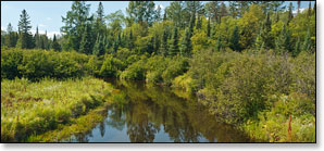
The surrounding landscape varies from bottomlands of tall marsh grasses and dense northern lowland forest, to rocky ledges and steep sloping hills. When the forest closes in it is often made up of: pine, spruce, box-elder, poplar, aspen and maple. Several large spring-fed sloughs join the river including the Wisconsin Slough, which is located two miles downstream from the Highway 139/189 bridge. Wildlife is abundant.
Canoe/Kayak Camping
There are two primitive, riverside canoe/kayak campsites in this segment. One is located at Twin's Rapids and the other is near Two-Foot Falls. Both are free and operate on a first-come, first-serve basis. Please limit your stay to one night only!
Season
The river is usually navigable throughout spring, summer and into fall. It can be scrappy in some places during periods of little rainfall in late summer and fall.
River Level Information
River Gauge Location: US Hwy 2 Bridge, MI (north side)
Suggested Minimum Level: 220 cfs / 3.5 feet
USGS Website: USGS Gauge @ Brule, WI