

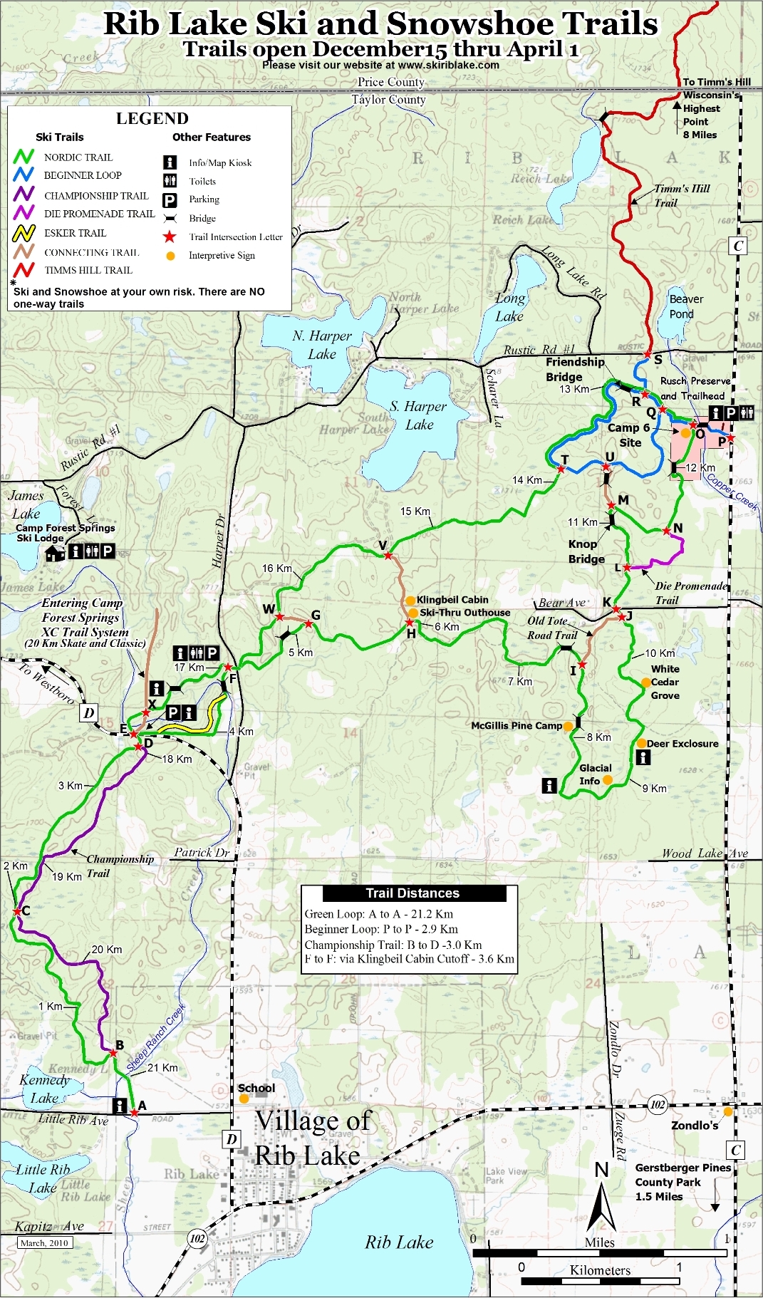
Rib Lake Ski & Snowshoe Trails
Trail Facts
| Novice: | 2.9k |
| Intermediate: | 24.1k |
| Advanced: | 3k |
| Grooming: | C+S |
Click or Tap for Local Forecast
Synopsis
Trail Review
LOCATION
North of Rib Lake (45 minute drive west of Tomahawk).
TRAILS
Grooming: Classic & skate. Multiple loop trail system.
Snowshoe Trails: Yes. Shared Trails.
TRAIL NOTES
Rib Lake Ski Trails are an excellent trail system developed and maintained by the The Rib Lake Ski and Snowshoe Club. Skiers will find a long, multiple-loop trail system through a splendid variety of terrain and scenery in a glacial moraine landscape. The trails run through several different forest types. Mixed hardwoods are most common, but there are several large stands of pines and hemlocks (Beginner's Loop, & Die Promenade Trail) ...and there are hills... mile after mile of fun, small, rolling hills.
Grooming is regular and is generally excellent for both skate and classic as conditions allow.
Sprinkled throughout the system are wooden bridges and historical sites. Most of the historical sites detail the rich logging history of the area, and others serve as rustic memorials to local families who kindly donated their land for public use.
The Rib Lake Trails connect with the Timm's Hill Trail (16.1 km), and High Point Ski Trails (14 km). Altogether that's a trail system of more than 60 km of trails!
"Ranging from the Beginners Loop to the Championship Trail, the trail system has been designed to encourage the novice and challenge the expert, while providing an enjoyable experience for skiers and snowshoers of all abilities."
"The most popular section of the trail is the two-mile beginners ski loop, which begins and ends at the Rusch Preserve on Hwy C. This gently rolling and wide scenic route includes the Friendship Bridge. At 14 feet in height and 43 feet in length, it is the longest bridge used exclusively for cross-country skiing in the lower 48 states."
"The Timm's Hill National Trail starts at the Rusch Preserve on Hwy C, and is also groomed for diagonal skiing, skate skiing, and snowshoeing. It travels 10 miles north and connects to an extensive ski trail system in Price County maintained by the High Point Ski Club around Timm's Hill, Wisconsin's highest point. "
_Rib Lake Ski & Snowshoe Club
LAND OWNERSHIP
Most of the trail system lies on private land donated for public use. The trails are maintained by the Rib Lake Ski & Snowshoe Club.
PARTNERSHIP / TRAIL MANAGEMENT
FEES
Donation box at all trailheads
FACILITIES
Parking, pit toilets, warming shelter on trail (firepit)
On-Site Equipment Rentals: No.
IN THE AREA
Motels, food, & gas (Rib Lake).
DIRECTIONS
South End: From the Hwy 102 & County D intersection in Rib Lake, take County D north for 0.4 mile and turn left (west) onto Little Rib Ave. Then go 0.4 mile to the trailhead located on the north side of the road.
County D Parking: From the Hwy 102 & County D intersection in Rib Lake, take County D north for 2.1 miles to the trailhead located on the north side of the road.
Thum's Parking: From the Hwy 102 & County D intersection in Rib Lake, take County D north for 1.9 mile and veer right (north) onto Harper Drive and go 0.3 mile to the trailhead located on the left (west) side of the road.
Rusch Preserve Parking: From the Hwy 102 & County D intersection in Rib Lake, take Highway 102 east for 2.1 miles and turn left (north) onto County C and go 2.7 miles to the Rusch Preserve parking area located on the left (west) side of the road.
TRAIL INFORMATION
Website: Rib Lake Ski & Snowshoe Trails