

Lower Wisconsin State Riverway
(LWSR1) Sauk Prairie to Spring Green, Wisconsin Trail Guide
Trail Facts
| Distance: | 20.4 miles |
| Skill Level: | Easy |
| Whitewater: | Flat |
| Approx. Paddle Time: | 10+ hours |
| Elevation Drop: | 31 feet |
| Average Gradient: | 1.5 fpm |
Synopsis
Trail Review
The 20.4 mile reach of the Lower Wisconsin Riverway, between Sauk Prairie and Spring Green, is by far the most popular of the entire LWSR for single-day and overnight canoe trips of various lengths. The river seems to have more of a 'fun' atmosphere in this stretch when compared to the other segments downriver. High sandy banks and long beaches are common, backed by tall grasses, dense thickets of hazelbrush, occasional meadows and open savanah.
Paddlers will often be greeted by up to a hundred sandbars in this segment during normal summer flows, providing many excellent opportunities to stop and play in the shallow waters and camp overnight (no fee!). This magical combination of water and sand creates a fun and inviting atmosphere which many take advantage of.
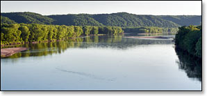
One of the more prominent features of this segment is Ferry Bluff, located about 2.5 miles south of the Mazomanie Access. There is a small sandy landing on river right at the base of the bluff with a hiking trail to the top, where you'll be rewarded with excellent panoramic views of the Wisconsin River Valley. Across from the Bluff is Mazomanie Beach, in lower flows this beach is often quite large and provides a fun place to stop and rest or play.
As the river flows south and west past the heights of Ferry Bluff, a dense hardwood forest often canopies the river banks and the islands become larger and more frequently wooded. Maple trees are dominant, but ash, oak, basswood, and river birch are common.
A recommended day trip for newbies would be to put-in at either the Mazomanie or Sauk Landings and takeout at the Arena Canoe Landing. Remember to pack a lunch and take a fun break on one of the many sandbars!
Camping
Most multi-day trips occur between Mazomanie and Spring Green. There are typically a larger number of sandbars and sandy beaches suitable for camping during normal summer flows in this reach than downriver.
Devil's Lake State Park RESERVE A CAMPSITE
Governor Dodge
State Park RESERVE A CAMPSITE
Blue Mounds State Park
Devil's Lake State Park lies about 16 miles driving distance north of the Sauk Canoe Landing. The second most visited State Park in Wisconsin, Devil's Lake features a 360-acre lake surrounded by 500-foot bluffs. Recreational opportunities abound, including: miles of scenic hiking trails and overlooks (including a segment of the Ice Trail); rock climbing; sailing, canoeing and kayaking with boat rentals available; several huge shaded picnic areas; a nature center and two historic concession buildings. There are 3 family campgrounds with a total of 423 sites, and 9 group campsite that accommodate a total of 240 people. 364 sites are reservable.
Check out the excellent Devils Lake State Park Visitor Guide website for more information on visiting the park.
Governor Dodge State Park is just 11.6 miles south of Peck's Landing at Spring Green on Highway 23. The park offers: forty miles of hiking trails; eight miles of mountain bike trails; twenty-two miles of horse trails; eight picnic areas; and a pair of lakes with swimming beaches, and boat launches for canoeing and kayaking. There are two family campgrounds at Governor Dodge; Cox Hollow and Twin Valley, with a total of 269 campsites. Other types of camping include: six backpack sites; eight group sites (15 - 40 people per site); and eleven horse campsites.
Densely wooded Tower Hill State Park sits next to the river near the end of this segment and offers a small family campground with easy river access for canoe camping. Although this park doesn't exude the same “fun energy level” as Devil's Lake or Governor Dodge, it does offer: scenic bluff trails, eleven shady campsites, a picnic area, restrooms, water, and a very unique historical site that is well worth a visit. Camping is on a first-come, first-served basis.
About 20 miles south of the Mazomanie Boat Landing lies Blue Mounds State Park: “Perched atop the highest point in southern Wisconsin, Blue Mound State Park offers spectacular views and unique Locationgeological features. A swimming pool is available in during summer. Over 20 miles of scenic hiking, off-road biking and cross-country ski trails, as well as a family campground, access to the Military Ridge State Trail with bike-in campsites and a rustic cabin for people with disabilities make Blue Mound a popular destination year-round.” _WI DNR.
67 of the 89 campsites are reserveable.
Season
The river is usually navigable throughout spring, summer, and fall. It can be scrappy in places during periods of little rainfall in summer and fall. Paddlers should avoid the river in early spring, or whenever water levels are especially high.
River Level Information
River Gauge Location: State Hwy 80 Bridge at Muscoda
USGS Website: USGS Gauge @ Muscoda, WI
Phone Contact for River Info: Contact local shuttle service / livery (see Local Business Directory page).
Always check the local weather forecast before paddling on the LWSR. Also, even if the local forecast calls for sunny conditions, talk to a local outfitter about possible river surges before embarking on an overnight trip! Although it may be sunny in the LWSR, any kind of heavy rainfall upriver can result in an unexpected rise in river levels. Although this set of conditions doesn't happen very often, it occasionally does, and is something to be aware of.
Suggested River Levels
| Below 4,000 cfs |
Very shallow riverway, many large sandbars. You may have to step out and push several times. Excellent conditions for sandbar camping! |
| 4,000 cfs to 10,000 cfs |
Normal summer conditions, many medium to large-sized sandbars. Shallow riverway at low end of this range - occasionally, you may have to step out and push. Excellent conditions for sandbar camping! |
| 10,000 cfs to 14,000 cfs |
Above normal flow conditions, noticeable undercurrents developing, especially in lee of sandbars and islands. Sandbars are smaller and fewer in number at high end of this range. Usually acceptable conditions for sandbar camping. |
| 14,000 cfs to 17,000 cfs |
High flow conditions. Undercurrents above 4 mph develop, especially in lee of sandbars. Sandbars are few in number. Sandbar camping not recommended in this range. |
| 17,000 cfs to 20,000 cfs |
High flow conditions with deceptively powerful undercurrents developing. Overnight camping on sandbars and beaches not recommended! Can be a fun day trip however, many small channels open up in lower reaches of the LWSR - be careful of strainers in narrow confines. |
| Above 20,000 cfs |
Paddling not recommended! |