

Synopsis
Paddling the Chippewa River
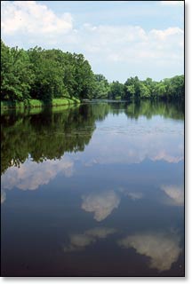
This wide, scenic river flows through a rural countryside of mixed hardwood and softwood forests, beautiful meadows, dairy farms, and agricultural communities. Birch, oak, maple, basswood, aspen, and conifers often overhang the shoreline, canopying lush undergrowth. The river is very popular for its excellent fishing with muskellunge, northern pike, walleye, smallmouth bass, and a variety of pan fish often pulled from the waters.
The majority of the 48 mile reach from the Arpin Dam outside Radisson, to the Flambeau River Confluence, features mostly calm water. The most challenging whitewater occurs in two places; at Bellile Falls Rapids, a long class 2 located just below Arpin Dam (C1), and in Segment C2 below the Highway D bridge. The latter features numerous pitches of riffles and class 1 rapids over a nine-mile section. The remaining 36 miles are mostly flatwater with occasional riffles and low hazard rapids.
Paddlers should take special care after a release from the Arpin Dam, or after periods of heavy rainfall, as the rapids can produce large waves that can potentially swamp an open deck canoe. Also be aware that the current can be deceptively fast, especially along the shoreline.
The river is the centerpiece of the Upper Chippewa River Basin. The Flambeau, Jump, Elk, Thornapple, and Couderay Rivers all feed into the Chippewa, draining an area roughly the size of Connecticut, more than 4,600 square miles.
The Chippewa River has a rich logging history The entire basin was logged from the 1850's to about 1906. The river provided a waterway to float cut timber from northern Wisconsin to the Mississippi River.
Camping
Wisconsin State Park/Forest Campgrounds
The nearby Flambeau River State Forest has two family campgrounds at: Connor's Lake (29 sites), and Lake of the Pines (30 sites). Both are rustic campgrounds with no electric sites. Connors Lake is open from the Thursday before Memorial Day, to the Tuesday after Labor Day, and offers 29 reservable sites.
Brunet Island State Park is on an island in the Cornell Flowage of the Chippewa River, just outside of Cornell Wisconsin. The park is about a 25 minute drive south from the takeout of Segment C4 (Flaters Resort). There are two campgrounds with a total of 69 sites, 52 are reservable. Many sites are on the shoreline of the Flowage.
Chequamegon-Nicolet National Forest Campgrounds
The Chequamegon-Nicolet National Forest has one campground nearby, about 26 miles driving distance northeast of Radisson (C1). Scenic Black Lake Campground has 29 secluded sites, all of which are reservable.
Season
The river is usually runnable from early spring through late fall. Novice canoers and kayakers need to exercise extra caution when the waters levels are high. High flows generally occur through early May, after periods of heavy rainfall, and when the Arpin Dam has a release. This is an excellent river to paddle in late summer and fall when many other rivers are experiencing low water volume. Contact the Wisconsin DNR office in Ladysmith (715.532.3911) for water levels before paddling the river.