Synopsis
Paddling the Black River

Begining at the outlet of Black Lake near the small village of Chelsea in Taylor County, the Black River flows for nearly 200 miles before emptying into the Mississippi River near Onalaska. From its source, the river begins as a narrow stream, meandering westward through a dense northern hardwood-conifer forest. The river bends southward west of Medford, and gradually begins to widen from additional, accumulative flows of numerous feeder streams. Beginning at the Sawyer Ave Bridge, west of Medford and north of Highway 64, the final 100+ miles of the Black River are considered navigable for paddling, though the first 15 miles are barely so due to frequent deadfall.
Canoers and kayakers will find the upper Black to be narrow and intimate. Trees often arch over the river creating a tunnel-like effect. Maple, beech, birch, and ash are dominant covering a varied understory, while pine and spruce canopy the banks where the soils become sandy. This long upper region features numerous riffles and class 1 rapids along with a large number of small islands and weedy gravel bars. The islands often create narrow, winding, high-speed channels which can be a blast to maneuver through, yet often present dangerous situations due to the large number of fallen trees and strainers.
The surrounding landscape becomes increasingly hilly as the river flows southward past Greenwood, then Neillsville. The rapids become more difficult as well. Paddlers will find numerous pitches of fun class II's when water levels are adequate, which is usually in the spring and early summer. Several of the rapids rate class III in high flows, especially during the winter melt-off.
The first of two dams on the lower Black River is located at Hatfield, which forms Lake Arbutus, a beautiful and popular summer destination for summer vacationers! Picturesque rock formations, and gorgeous stands of tall white pines are located along the river, above and below Lake Arbutus.
The steepest gradient of the river lies in the eight mile stretch below Lake Arbutus, south of the Hatfield Dam. Kayakers will find at least four class IV rapids and a number of class II's in this short reach when water levels are high. These rapids are best run in the spring or when the Hatfield dam has a release.
The difficult whitewater ends a few miles above Hall's Creek Landing, and the character of the river changes from narrow and steep, to wide, shallow and slow, though the river bed continues to be quite rocky. Not far below Hall's Creek, the slow-moving river flows past nearly continuous 'minor' rock formations along both banks of the river, which become more dramatic as the river approaches the Black River Falls Dam (the second, and final dam on the Black). The river in this stretch is mostly quietwater with a few riffles and one wavy class I rapids.
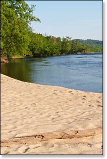
Below Black River Falls, the calm waters of the lower Black run through a geologically unique area of Wisconsin, where the northern range of southwest Wisconsin's driftless region - with its tall scenic bluffs and rock formations - overlaps the southern edge of Wisconsin's northern hardwood-conifer forests. In this region, you will find the most popular segments of the Black River for canoeing and kayaking, the 21 mile stretch between Irving and North Bend, where sandbars and big sandy beaches seem to appear around every bend and the sandy river bottom is often only a few inches below the water's surface. This part of the river is also very popular for canoe/kayak camping excursions. Overnight camping on the sandbars and islands is permitted ($ free). There are enough access points along the lower Black River that you can plan a trip that could last a few hours or several days.
The river is also very popular for fishing. Numerous deep pools, and submerged deadfall in the river provide anglers plenty of opportunities to fish for small mouth bass, northern pike, and musky.
Visitors to the Black River Falls / Lake Arbutus area will find plenty of outdoor recreational activities besides paddling. The nearby Black River State Forest features three developed family campgrounds. Several beautiful county and private campgrounds are also in the area. The Black River State Forest and the Wazee Lake Rec Area feature a number of scenic hiking, mountain bike, and horse trail systems suitable for all skill levels. The "Foundation Trail", one of the best 'rural', paved walking / biking trails in Wisconsin is located in Black River Falls. An 18 hole golf course is nearby. Other area attractions include motorcycle and atv trails, numerous fishing lakes and streams, boating, water skiing, a community theater, and the Ho-Chunk Majestic Pines Casino for a little night-time excitement.
Camping
The Black River State Forest maintains a small, primitive canoe/kayak campground for overnight camping which is located in segment BK2 below Hawk Island. The camp offers two tent sites. Each site has a picnic table, fire ring and a shared toilet. Camping is free and operates on a first-come, first-serve basis. You must limit your stay to one night only!
There are three family campgrounds inside the Black River State Forest with a total of 97 campsites. The Castle Mound Campground is open year-round and offers 35 total sites. 14 are electric. The "campground includes an accessible shower building, accessible flush and vault toilet buildings, firewood sales, indoor picnic shelter, garbage and recycling station and sanitary dump station." All of the sites are reservable.
There are two rustic campgrounds: East Fork (24 sites) and Pigeon Creek (38 sites). All of the sites are reservable.
The State Forest also offers an indoor group camp and an outdoor group camp. Both are reservable online (the indoor group camp is electric with modern facilities!).
Season
The lower Black River is usually navigable throughout spring, summer and into fall. It can be scrappy in some places during periods of little rainfall in late summer and fall. The most consistent paddling conditions occur from Hall's Creek Landing, a few miles north of Black River Falls, to the Mississippi River confluence. If you put-in below the dam, at Cormican Landing in Black River Falls, you will have unobstructed paddling (no dams) all the way to the Mississippi River.
Water levels are a major factor in navigating the upper and middle reaches of the Black. The large number of riffles, boulder gardens, and rapids can be too shallow to paddle through when water levels are low. Spring-time and early summer are the best times to attempt the upper and middle reaches.

