

Pattison State Park
Big Manitou Falls, Little Manitou Falls, Wisconsin Trail Guide
Trail Facts
| Distance: | 0.5 to 3.2 miles |
| Exertion/Intensity: | Easy to moderate |
| Terrain: | Mostly flat |
| Elevation Gain: | Varies (see guide) |
| Trail Surface: | Paved & dirt paths |
| Rocks & Roots: | Occasional |
Synopsis
Trail Review
The Black River starts at Black Lake in eastern Minnesota and meanders for 22 miles before entering Pattison State Park in northwestern Wisconsin.
Shortly after entering the park, the river plunges over Little Manitou Falls and then rumbles through a long series of rapids and minor waterfalls before slowing and forming beautiful Interfalls Lake, a man-made lake created by a small damn at its northern end. Soon after Interfalls Lake, the river roars over the massive 165-foot Big Manitou Falls into a deep gorge. The gorge levels off considerably within a mile as the river continues north, leaving the park and eventually joining the Nemadji River.
Other attractions at Pattison State Park include: a large shady day-use/picnic area, a sandy swimming beach on Interfalls Lake, an historic bathhouse, 10 miles of hiking trails, a nature center, a recently renovated shelter with electricity, and a modern family campground with 59 campsites.
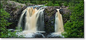
Big Manitou Falls
At a towering 165 feet in height, Big Manitou Falls are the fourth highest waterfall east of the Rocky Mountains. These impressive falls roar through several drops over a high basalt escarpment into a deep and narrow, rocky gorge. Dense stands of red and white pines, cedar, and spruce surround the falls and cover the inner walls of the gorge. Below the falls, the river flows out of sight around a sharp bend, running north into the lower gorge. A few miles north of the park, the Black joins with the Nemadji River and eventually spills into Lake Superior, just east of Superior / Duluth.
The escarpment that forms the waterfalls and the rocky walls of the gorge are remnants of two ancient geologic events. First, lava flows covered the surrounding region approximately 1.2 billion years ago. Then, a massive fracturing of the basalt bedrock occurred about 500 million years ago. This fracturing, or crack, is named the Douglas Fault, and starts on the floor of Lake Superior just north of Ashland and extends in a long westward arc to just north of the Twin Cities in Minnesota. The Douglas Fault is a thrust-fault, where the bedrock south of the crack was pushed up at a 50 to 60 degree angle over the bedrock north of the crack. Today, the fault-line is most visible where it crosses the riverbed several hundred yards down-river from Big Manitou Falls.
For visitors, this is a nicely developed and well-maintained scenic area with numerous overlooks and viewing platforms, several with unobstructed views of the falls from both sides of the gorge. All of the overlooks are connected by a small network of paved walking paths. A pedestrian bridge crosses the river just above the falls and below the highway, providing easy access to both sides of the gorge. Visitors will find the most complete views of the falls from the south overlook on the west side of the river.
Little Manitou Falls
Located about 1.5 miles upstream from the larger Big Manitou Falls, Little Manitou Falls occurs where the Black River splits into two main channels and drops thirty-one feet over a wide, basalt-rock ledge into a small basin surrounded by rocky walls and dense forest.
There are several excellent viewpoints of Little Manitou Falls with unobstructed views of the falls. You may also view the falls from inside the shallow basin. Watch your footing as you descend the short, steep slope; and as you walk on the wet, loose, uneven rocks inside the basin.
More Information
Website: Pattison State Park Wisconsin DNR website.
Phone Contact: 715.399.3111
Trail Access Fee: Yes, WDNR Vehicle Admission Sticker required. Daily or annual.