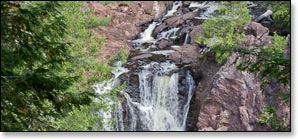
Copper Falls State Park
The Doughboy's Trail, Waterfalls & Scenic Gorge, Wisconsin Trail Guide
Trail Facts
| Distance: | 1.7 miles |
| Exertion/Intensity: | Easy to moderate |
| Terrain: | Flat & steep stairs |
| Elevation Gain: | <500 feet |
| Trail Surface: | Wide, packed earth |
| Rocks & Roots: | Occasional |

Synopsis
Trail Review
Copper Falls State Park is located in northern Wisconsin near the town of Mellen, a short drive south from Ashland. The highlight of the park is a dramatic, two mile-long river gorge where the Tyler Forks River joins the Bad River in a deep and narrow, rocky gorge and plunges over several dramatic waterfalls. The main waterfalls are Copper Falls (29 feet) and Brownstone Falls (30 feet) along with a beautiful rapid called the Cascades.
Other scenic highlights include a large, conglomerate rock formation on the Bad River appropriately named "Devils Gate" and an observation tower with excellent views of the surrounding forest-covered hills and Lake Superior to the north.
Much of the development you see in the park today; wooden footbridges, log fences, and log buildings, were originally constructed in the early 1920's by returning veterans from World War I. More work was done in the late 1930's by the Civilian Conservation Corps. Today, the original log buildings, bridges, and fencing add a great deal of rustic charm and character to the park.
Overall, Copper Falls State Park rates as one of the most beautiful parks in Wisconsin, and is very popular for families and couples.
The Doughboy's Trail
The Doughboy's Trail is a scenic, self-guided nature trail in a 1.7 mile loop around the rugged Bad River Gorge and a small segment of the Tyler Forks River. There are numerous observation decks and scenic overlooks that provide gorgeous, dramatic views of: Brownstone Falls, Copper Falls, the Cascades, and Devils Gate. Signs along the trail detail the unique geologic history of the river, waterfalls, rock formations, and surrounding area.
Much of the trail runs along the top of the Bad River Gorge and is surrounded by pine forest with limited views into the gorge. However, the unobstructed views from the numerous observation decks and scenic overlooks easily makeup for the lack of visibility from the trail. The pine scented air and the constant, steady roar of the falls add to the experience.
The trail is mostly flat and level except where it nears Devil's Gate, where several flights of stone steps built into the hillsides on both sides of the river lead down from the top of the gorge to the river shorelines. It is recommended that you walk the trail loop in a clockwise direction. A relaxed stroll around the trail with stops at most of the scenic points takes about two hours.
Disabled Access
The entire eastern segment of the trail - about a half-mile in length - from the twin observation decks above Brownstone Falls to the wooden footbridge overlooking Copper Falls (east side of the river) is graded for wheelchairs. There is a small, separate parking area that is designated for disabled access only.
Concession Building
The concession building sits between the main day-use area parking lot and the trailhead of the Doughboy's Trail. Concessions include hot food, sandwiches, soda, and water along with souvenirs and post cards. Inside the building you will also find a very cool world map where hundreds of previous visitors have placed pins to mark where they're from. There are also restrooms with running water and an indoor children's play area. The concession building is open every day during the summer.
Picnic Area
A large, beautiful picnic area surrounds the parking lot and features: picnic tables, bbq grills, water, a covered pavilion, a well-kept grassy lawn, and plenty of shade beneath tall white pines and huge oak trees. A designated pet area is located off the southwest end of the parking lot.
More Information
Website: Copper Falls State Park
Phone Contact: 715.274.5123
Trail Access Fee: Yes, WDNR Vehicle Admission Sticker Required.

